Weak swells continue with a fun weekend ahead

Victorian Surf Forecast by Craig Brokensha (issued Monday 4th April)
Best Days: Wednesday morning east of Melbourne for the keen, Saturday until mid afternoon all regions, Sunday morning
Features of the Forecast (tl;dr)
- Small, inconsistent mid-period W/SW swell building tomorrow PM, peaking Wed, easing Thu
- Light W/NW tending S winds on the Surf Coast tomorrow, light S/SW tending S east of Melbourne
- Light E/SE-SE tending stronger SE winds Wed
- Gusty E/SE-SE winds Thu and Fri with a small SE windswell
- Inconsistent, mid-period W/SW swell Sat with N/NE tending E/SE winds, easing Sun with strong N tending N/NW then S/SW winds
- Small, short-lived pulse of SW swell filling in Mon, easing Tue
- Light N/NW tending S winds Mon, gusty S/SE Tue
Recap
A poor weekend of surf with a mix of easing mid-period S/SW swell and localised SE windswell with fresh SE winds on Saturday, lighter yesterday. Today conditions are clean across the Surf Coast but with tiny leftovers, bumpy and 2-3ft to the east.
This week and weekend (Apr 5 – 10)
The next couple of days look to remain poor for surfing in general with waves for the desperate if you're really keen.
Tomorrow will start tiny with light W/NW winds on the Surf Coast and a light S/SW breeze to the east but we should see a very inconsistent and small, mid-period W/SW swell moving in through the afternoon, peaking on Wednesday.
The source of this swell was a persistent but weak mid-latitude frontal progression pushing through the southern Indian Ocean through last week and into the weekend.
The Surf Coast should build to an inconsistent 2ft tomorrow afternoon with moderate S'ly winds, 3ft to the east with Wednesday seeing 2ft+ and 3-4ft sets respectively. The Mornington Peninsula and Phillip Island will be best dawn Wednesday with a light SE-E/SE breeze before a strong high moves in during the day, squeezing against a deepening surface trough off the southern NSW coast. This will bring strengthening SE winds, shifting E/SE through the day.
Strong E/SE-SE winds will persist through Thursday and Friday as the trough remains slow moving off the East Coast and swell wise, Wednesday's swell will be on the ease, mixed in with some poor SE windswell across the Surf Coast.
A small pulse of mid-period SW swell is due Friday but it'll be below Wednesday's and with those average winds.
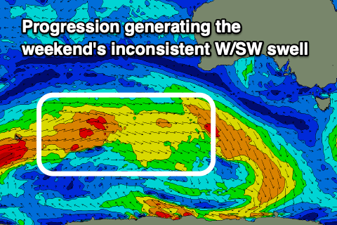 Some slightly better, inconsistent mid-period W/SW energy is due Saturday, easing through Sunday generated by another relatively weak but elongated frontal progression that's currently firing up towards Western Australia. Fetches of strong W/SW winds will be aimed through our medium-range swell window, with inconsistent sets to 2ft generally expected on the Surf Coast with the odd 3ft'er on the magnets, 3-5ft to the east.
Winds will improve as the high starts to move east on the weekend, bringing a light N/NE breeze with fresh E/SE sea breezes and stronger N winds Sunday morning ahead of a trough and evening S/SW change.
This trough will deepen into a weak low on approach to us during the weekend (quickly dipping south-east), producing a small short-lived pulse of mid-period W/SW swell for Monday afternoon and Tuesday though at this stage only to 2ft to maybe 3ft on the Surf Coast and 4ft+ to the east. Winds look N'ly early but another trough looks to bring a S'ly change when the swell peaks through the afternoon.

Following this there's still nothing significant on the cards as weak polar and mid-latitude systems push through our swell window. We'll have a closer look at the outlook for the rest of next week on Wednesday though.
Comments
12th onwards looking dire atm!
Not much on offer next week for the comp.
Small Winki maybe. Looks too small for Bells.
I thought that’s when things improve just slightly. W type winds at least.
Not in the latest update.
Just saw that! Winds looked good before. Now it’s rubbish winds.
Fark me just saw that model update too. Thought there'd be some fun small clean options all week and now it's a complete shitshow again. I'm done.
Looks like it has swung back again ....
Always pays to be extremely cautious about forecasts that swing wildy from model run to model run (i.e. from "good surf" to "bad surf"). Suggests poor initialisation and thus low confidence in the outcome.
Possible signs of life, here's hoping.
Is La Nina having an impact on swells into Indo? Or is the swell window/distance too broad for it to be an issue?
Thinking of a trip to provide light at the end of this tunnel.
Yep it is, no size there either.
Yayyyyyyyyy! Weak 2ft and offshore for the weekend when it'll be packed like sardines after another week of shit.
Not that I really care what surf the pro's get beyond what it means for my own surfing, but I imagine if the comp is at Winki then the viewing options are pretty limited & ordinary? I haven't watched the comp when it's at Winki before, obviously it's all set up right now for Bells.
When at Winki you’ll be sitting in the car park watching a big screen - i only go if it’s bells but guess it depends what you’re after
I find my lounge room with a big flatscreen TV to be the best vantage point if the comp's on at Winki (or Bells).
I can ride my pushy there in 10 minutes but would rather stick pins in my eyeballs than get caught up in that overcrowded, temp structures everywhere clusterfuck.
Your 10min bike ride is nearly longer than I've spent actually watching a pro comp, in person or on TV, so at best it might be TV for me too then. Unless I feel like some exercise then I might ride there too for a look.
Bike date?
Pity the crew trying to run the Trials on Thursday!
Update on the local winds tomorrow.
Looking better and E/NE all morning ahead of stronger E/SE winds into the afternoon.
Top WOTD mate, that's some serious water moving around out there, you're a brave man.
Thanks WAG!
Wowee, how’s the latest model update for the waiting period for the comp, several different swells from 3-5 ft and mostly westerly winds, imagine if that comes to fruition, WSL will have seriously lucked out
Man I can't believe this, after all the crap that we have been through over the last 8 months!! The circus comes to town and from the 11th, every morning is going to be firing!!! Wtf!!
It won't be ;)
I sure hope you're right ;-)
Monday, Tuesday, Thursday, Friday yeah it will :-)
Wait for the latest model update..
With so much change in the day to day model updates are you confident yet on which way it will end up Craig ?.
My feelings are we'll fall somewhere in between. Not doomsday but also not pumping. Great to watch unfold though. Will have a much clearer idea tomorrow.
I was thinking for the titles, if you run out of ideas, you could do "Poor Windy Outlook 2: the sequel"
And joining us in the booth this evening, big fan of SWELLNetball, Craig Brokensha, who plays, as you know, Forecaster cut-up "Craigoss" on the new hit comedy series “Vic Forecast Notes?" airing between "Recycled Junk" starring Sou’ Easter and "Same Old Crap" featuring teen heartthrob Insert West Coaster Surfers name here, all part of the great Autumn lineup on our network's "Who gives a rat's ass?" Thursdays.
Lifelong respect to answer of movie reference.
Baseketball. A true classic.
Haha.
3-4 foot 10 knots west sw before midday is epic for a comp compared to how it's been for the last 5 months