One day to target this period

Western Australian Forecast by Craig Brokensha (issued Friday May 30th)
Best Days: Sunday, hopefully next Saturday
Features of the Forecast (tl;dr)
- Mix of easing W/NW swell tomorrow and building, inconsistent SW groundswell, peaking later, easing Sun
- Strong W tending SW winds tomorrow (possibly variable Perth/Mandurah early)
- Moderate to fresh E/NE tending fresh N/NE winds Sun
- Strong N/NE tending N/NW winds Mon
- Large W'ly groundswell Tue with strong N/NW winds (outside chance of N/NE winds in Margs early)
- Easing swell Wed with strong N/NW tending W/NW winds
- Smaller Thu with strong S/SW winds
- New, inconsistnet, moderate to large W/SW groundswell building Fri with S/SE tending S/SW winds (E/SE to the north in the AM)
- Swell holding Sat AM, easing with hopefully morning offshores
Recap
An inconsistent W/SW groundswell due yesterday showed to 4-5ft across the South West with doable conditions under a strong, morning E/NE breeze, less favourable and more NE into the afternoon. Mandurah was tiny and wind affected with a building N/NW swell, cleaner across Perth.
This morning there’s a bit more west energy in the mix from the top of a weakening mid-latitude low west of us and this has offered peaky 2ft+ options across Perth, choppy in Mandurah and poor across the South West. Winds are due to hold from the N/NE most of the day before shifting NW across all locations mid-late afternoon.
This weekend and next week (May 31 - Jun 6)
The weakening mid-latitude low linked to the current run of strong north winds and increasing W/NW energy will move across us overnight, leaving strong W tending SW winds tomorrow across the South West, possibly variable further north around Mandurah and Perth.
Swell wise, the W/NW energy should ease, with an inconsistent long-range SW groundswell on the build, coming in at 2ft across Mandurah and Perth.
The South West should build to 6ft to occasionally 8ft, but Sunday is still the pick with easing 6ft+ sets and 2ft waves to the north.
Winds are due to shift quickly offshore from the E/NE on Sunday, moderate to fresh in strength, then tending N/NE-NE into the afternoon.
Monday will be windier and smaller with strong N/NE tending N/NW breezes due.
Now, this will be ahead of a strong, slow moving mid-latitude low moving in from the west, with it forming tomorrow. This low will sit just north of Margaret River’s latitude, with a tight but very intense fetch of severe-gale W/SW winds forecast to be projected through our western swell windows.
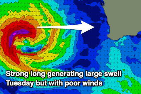
A large W’ly groundswell will be generated by these winds for Tuesday morning, though unfortunately the slow movement of the low will see strong N/NW winds developing across all locations through the day, with an outside chance of dawn N/NE winds in the South West.
Size wise the swell should come in at 10ft+ or so in the South West, 5-6ft across Mandurah and 3-5ft in Perth, easing through the day then smaller and weaker Wednesday under persistent N/NW tending W/NW winds.
Thursday still looks poor as we fall under the backside of the low with strong S/SW winds due, possibly shifting S/SE across the South West by Friday morning, more E/SE to the north.
Swell wise, this looks to occur with the arrival of some good, long-range W/SW groundswell generated by a flurry of strong Southern Ocean frontal activity to the south of South Africa today and tomorrow.
The strongest and best front will move through today and tomorrow, with a broadening, weakening fetch of severe-gales due to produce a moderate + sized, long-period groundswell for Friday afternoon and Saturday morning.
At this stage the South West looks to come in at 6ft to occasionally 8ft, 2ft+ Perth and Mandurah but we’ll review this Monday.
There’s also the chance that a deepening mid-latitude low directly south-west of us, spoiling local conditions. More on this Monday, have a great weekend!