Smaller run of surf with fun windows for the exposed beaches

Victorian Forecast by Craig Brokensha (issued Wednesday July 23rd)
Best Days: This afternoon Surf Coast, tomorrow morning Surf Coast (later exposed beaches to the east), beaches Friday/Saturday and Tuesday
Features of the Forecast (tl;dr)
- Moderate sized, mid-period W/SW swell building today under W/NW winds, easing rapidly tomorrow under W/NW-NW winds (tending N/NE to the east later PM)
- Small, inconsistent mix of SW groundswell and mid-period W/SW swell building Fri, holding Sat, easing Sun
- Strengthening N/NE tending NE winds Fri, strong N/NE Sat
- Mod-fresh NW tending stronger W/NW winds Sun
- Small, weak W/SW swell Mon with strong W/NW winds
- Small, inconsistent SW groundswell Tue with N tending variable winds
Recap
The surf backed off through yesterday with strengthening northerly winds, coming in tiny on the Surf Coast while to the east we continued to see workable 3ft sets across selected magnets.
Today a new mid-period W/SW swell is on the build, generated by a strong mid-latitude low dipping south-east from the Bight. We should see the Surf Coast magnets reaching 3ft+ through the day with 5-6ft waves to the east under a persistent W/NW breeze.
This week and next (Jul 24 - Aug 1)
Today’s pulse of mid-period W/SW swell will be short-lived thanks to it being generated directly west of us at the entrance to Bass Strait.
With the swell generating low weakening and moving east-southeast through today, we can expect the swell to fade back steadily through tomorrow from 2ft to possibly 3ft early on the Surf Coast and 4ft+ to the east under W/NW-NW winds. Later in the afternoon, winds are due to shift N/NE to the east, opening up cleaner options as the swell fades.
Now as touched on in Monday’s notes, an inconsistent, long-range SW groundswell is due to arrive through Friday, holding Saturday. The early morning will likely be undersized Friday, and the source is a distant but healthy stream of polar frontal systems near and east of the Heard Island region.
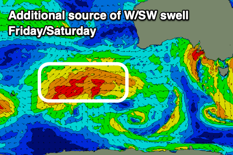
An additional W/SW swell should also be in the mix later Friday through Saturday, generated by the remnants of the progression projecting towards Western Australia last night.
The size off this progression will be limited, with slow 2ft+ waves due across the Surf Coast with 4ft+ waves to the east, easing Sunday.
Local winds will favour the exposed beaches with strengthening N/NE-NE winds due on Friday, stronger N/NE through Saturday, feeding into a broad, slow moving mid-latitude low moving in from the Bight. As it nears closer Sunday, winds will ease and shift NW then W/NW through the afternoon.
No major swell is due from this low at all, with it being angled more south to north and sitting too far up in the Bight, but as it moves across us Monday a weak, localised W/SW swell is likely, coming in at 2ft to possibly 3ft on the Surf Coast and 4-5ft to the east.
Strong W/NW winds will favour the Surf Coast again with winds kicking back to the north on Tuesday as the swell eases.
Taking its place though will be a new, long-range groundswell, generated by a strong but distant and short-lived polar low that’s currently just west of the Heard Island region. Swell from this source looks unlikely to top 2ft on the Surf Coast and 4ft to the east but the lighter north winds should open up fun options on those exposed beaches.
Longer term besides some further long-range groundswell energy with a bit more size, the outlook remains a little slow until the first weekend of August. More on this Friday.
Comments
Today’s report should be 1ft inconsistent. If that. Tiny still.
Yeah, not much happening as of yet. These afternoon highish tides won't help either.
off topic C but the snow forcast for next 7 days is outragous. i was scepictal of the june dump and had tail inbetween legs after that. but i have always had a rule of thumb that a S wind is reqired for cold enough air in vic for it to be cold enough to consistantly snow and not rain. is the below 1m predidiction possible for next 7 days with the storm so high up and not bringing cold air from south. on face value looks like rain inbetween snow storms.
Sorry forgot to get back to this Pigdog.
Yes generally WA peaking storms then loose their cold properties once moving further east and then onwards to Victoria, but this year we've seen these storms over WA coming in with tons of cold air in the upper atmopshere.
This means by the time they've reached the alps they're still cold enough to produce snow instead of rain.
This coming system looks marginal with rain turning to snow but there's enough for a nice top up in Vic, better for NSW.
Hi Craig,
Whilst on the topic of snow, Is it to early to tell what the predicted outlook is for the snow season in japan for 25/26 or would there be reasonable confidence ?. Season just gone was unreal.
Cheers
La Niña years are the best snow producers, this coming season looks like it could be neutral to weak La Niña state for Japan = better than average. You just want to avoid strong + IOD and El Niño years.
:)
35 out at Winki this arvo!
Torquay seems to have gotten over the Winki Cam.
Udo, just saw the new profile pic hahaha.
Looking great across those exposed beaches now.