Average outlook ahead

South Australian Forecast by Craig Brokensha (issued Friday July 25th)
Best Days: Monday South Coast
Features of the Forecast (tl;dr)
- Inconsistent mix of SW groundswell and mid-period W/SW swell buiding this afternoon, holding tomorrow
- Strong NE-N/NE winds today, strengthening from the W/SW-SW tomorrow (W/NW early Victor)
- Building windswell late tomorrow on the Mid, easing Sun with strong SW winds
- Modrate sized, mid-period S'ly swell building Sun down South, easing Mon with W/NW-NW tending N/NW winds
- Small-moderate sized, inconsistent SW groundswell Mon PM and Tue AM with N freshening NE tending E/NE winds
Recap
The Mid Coast was tiny and wind affected yesterday while the South Coast came in cleaner but the swell from Wednesday dropped right back to a slow 2ft.
Today we’ve got dreary, wet weather as a slow moving mid-latitude low moves across us, but a mix of W/SW and SW swells are on the build with NE winds favouring selected breaks.
This weekend and next week (Jul 26 - Aug 1)
We’re seeing an inconsistent mix of long-range SW groundswell and mid-period W/SW on the build today, with the Mid Coast expected to reach 1-2ft this afternoon (with gusty N/NE winds), holding tomorrow while the South Coast offers 2ft to occasionally 3ft sets.
Unfortunately, local winds will shift W/SW and strengthen through tomorrow as the low moves east of us, with the Victor region likely seeing dawn W/NW winds. With the limited window it won’t be worth chasing hard.
This strengthening wind is likely to kick up some additional windswell through the afternoon, with it holding 2ft Sunday morning across the Mid Coast, easing through the day.
Unfortunately strong SW winds will persist Sunday, creating poor conditions across all coasts and writing off the weekend surf wise.
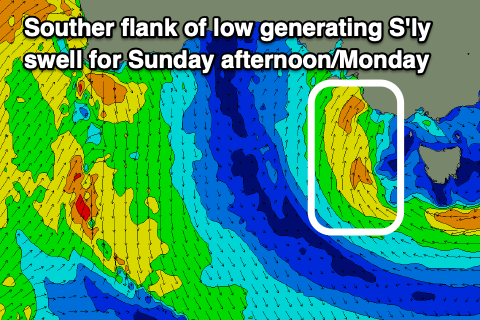
Monday is still looking to be the pick of the period, as we see a moderate sized increase in S’ly swell from the southern flank of the low Sunday afternoon, starting to ease back through Monday morning as winds shift W/NW-NW, lighter N/NW into the afternoon.
Fun, easing 3ft to possibly 4ft sets are due in the morning, smaller into the afternoon as a new, long-range SW groundswell arrives.
The source was a strong polar frontal progression that fired up around the Heard Island region earlier this week, with inconsistent 2ft to possibly 3ft sets due across Middleton into Monday afternoon, easing Tuesday morning from a similar size.
Local winds on Tuesday look less ideal and fresh out of the NE tending E/NE, with S/SE winds due to develop Wednesday as a trough moves in from the west.
Otherwise the outlook remains slow with nothing of note until later in the week, when a stream of south-east dipping storms from the south of Western Australia bring small to moderate levels of groundswell.
Unfortunately troughy weather will bring S’ly winds mid-late week, likely improving next weekend when the most size is due, but more on this Monday. Have a great weekend!
Comments
The dream run is over!!!!
Yeh, sorry, y'all, at least dirty grey washing-machine windswell might shift some algae. What's the deal with the kid getting shot in Seaford, Midders?