Indonesia/Maldives forecast Jul 24

Indian Ocean Basin analysis by Craig Brokensha (issued Thursday 24th July)
This week through next (July 25 - Aug 8)
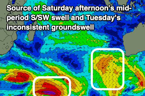
The surf is small across the region but into tomorrow afternoon, we should see a new, inconsistent S/SW groundswell building ahead of some larger mid-period energy into the weekend.
As touched on in Tuesday’s notes, the groundswell component was generated in our far swell window, only coming in around the moderate to possibly large size range, while a secondary healthy but relatively weak surge of S/SW-SW winds up towards WA yesterday and today has generated a larger, more consistent but weaker S/SW swell.
Both are due to peak through Saturday, biggest into the afternoon and the models are incorrectly combining the two and over-forecasting the size.
What we should generally see is sets to the 8ft range across the magnets Saturday afternoon (much smaller elsewhere), easing into Sunday.
The next increase in swell is due Tuesday, being another, inconsistent, moderate + sized S/SW groundswell generated by a strong but tight polar low around the Heard Island region through yesterday.
No major size is due from this source, and we’re set to see a weaker but slightly larger mid-period S/SW swell for the Wednesday, generated by another weak front pushing up towards Western Australia over the weekend.
This system looks weaker than the current front and the size is being over-forecast again by the models. We’ll be lucky to see 8ft sets from this system, mostly likely coming in at 6ft+ before easing into the end of the week.
Longer term there are hints of a stronger frontal progression generating a large, possibly significant SW groundswell into the week starting the 4th of August. More on this next Tuesday.
The current S/SE-SE trades are expected to shift more SE through tomorrow, holding through the weekend before strengthening through next week. The trades may start to weaken later in the week and early each morning, light local land breezes are due.
Over the in the Mentawais, our mostly variable winds that are tending E/SE-SE across southern locations will persist tomorrow, freshening a touch through the weekend but more so stronger into early-mid next week. Later week winds should become more variable.
These strengthening trades will kick up a mid-period S/SE swell for early-mid next week thanks to a robust fetch of SE winds developing south of the islands, easing a little later week.
----------------------------------------------
Maldives:

Moderate + levels of S/SE trade-swell should be in the water currently with the groundswell from yesterday abating, and we should see this energy persisting tomorrow and through the weekend ahead of larger levels of energy into early next week.
This will be thanks to an expanding fetch of strong E/SE-SE trades from south of us to Indonesia, with the fetch reaching maturity through early next week.
This will result in the swell becoming large from the S/SE through Tuesday next week, easing slowly from Wednesday thanks to the fetch weakening while tending more SE in nature.
Otherwise S’ly groundswell wise, background pulses from this weekend into early next week will be below that of the trade-swell, though so larger energy is on the cards later next week from the strong progression firing up from the south of South Africa. More on this next Tuesday.
Eastern Indonesia:
Moderate + sized, inconsistent S/SW groundswell building later tomorrow, peaking Saturday mixed in with a larger mid-period S/SW swell for the afternoon to 8ft across exposed breaks. Swell easing Sunday.
Moderate + sized, inconsistent S/SW groundswell to 5-6ft across exposed breaks Tuesday.
Mod-large mid-period S/SW swell Wednesday to 6ft to rarely 8ft across exposed breaks, easing from Thursday.
Likely large SW groundswell for the week starting the 4th.
S/SE-SE trades today, shifting more SE through tomorrow, holding through the weekend before strengthening through next week. The trades may start to weaken later in the week and early each morning, light local land breezes are due.
Uluwatu 16-day Forecast Graph/WAMs
Western Indonesia/Mentawais/South Sumatra:
Moderate + sized, inconsistent S/SW groundswell building tomorrow, peaking Saturday afternoon to 6ft to occasionally 8ft across exposed breaks, easing Sunday.
Moderate sized, inconsistent S/SW groundswell for Tuesday to 4-5ft+.
Moderate + sized S/SE trade-swell for Tuesday to 4-6ft across exposed breaks, easing slowly from Wednesday.
Mod-large mid-period S/SW swell for Wednesday to 6ft+ across exposed breaks, easing Thursday.
Likely large SW groundswell for the week starting the 4th.
Generally variable winds this week, tending SE across southern locations with winds expected to freshen a little through the weekend and stronger into early-mid next week.
Mentawai 16-day Forecast Graph/WAMs
Maldives:
Moderate + sized S/SE trade-swell for tomorrow through the weekend to 4-5ft+ across the southern atolls, smaller Male.
Larger, building S/SE trade-swell from later Sunday but more so Monday, peaking Tuesday to 6ft+ across the southern atolls, smaller Male.
Slowly easing S/SE tending SE trade-swell from Wednesday.
Moderate to fresh SW winds across northern and central locations tomorrow, weaker W/SW-SW on the weekend, weaker SE to the south.
Increasing SE tending E/SE winds across southern locations on the weekend, more variable next week.
Comments
Latest notes are live.
Great notes Craigos,
There’s been whispers here in Ulus that 4 August swell could be a solid one. Are the models combining different swell trains though, like was the case for the 19 July swell?
It's all fallen apart a bit. Not overly strong but still large.
Nice size at lances right this morning, beautiful conditions about 10.00 am , some double overhead sets , south swell has the boats going elsewhere plus the wind is a lottery at the moment. A few coming through the office but you get cleaned up by the wide sets paddling back out which made it hard work . I was happy sitting wide and was about 50/50 on making barrels, some nice big faces to work with too . Apparently bigger tomorrow.
Just snapped a few with the iPhone, better conditions earlier, pretty consistent .


Sick! Groundswell is down tomorrow Supa, might be seeing the new S/SE trade-swell?
It was just some comments from guys that live here , wait and see . Meanwhile ……..OUT THE BACK !


Morning Craig , as usual you are on the money, not as big today but still some good well overhead sets , slight southerly blowing but still fun , paddled out first light and got a couple of hours in before tide swallowed it .
Thanks Supa! Appreciate the continued intel and verification.
Thanks Craig, head high up here today occasionally overhead, lotsa fun and such a lovely shaped wave even when small . I heard a rumble you may be going on holidays soon , if so enjoy and I will miss your reports .
Ha. You're like Udo! Still on the computer until mid August.
Great , I’m here until September 1 so your forecast will be much appreciated. Hope you get some quality family time with waves or whatever you're doing, enjoy. ( you’re not forking out $3000 USD for a mystery surf trip by any chance ? )
Bahahaha.
Don't tell me I just got scammed SF
Sounds like you and AW are having a blast SF
Bit of blasting coming from AW early hours of this morning , Brazilian BBQ last night .
Feijoada blasts