Large swells inbound

Western Australian forecast by Craig Brokensha (issued Monday January 13th)
Best Days: Protected spots Perth and Manudrah tomorrow AM once winds shift, Wednesday morning, Thursday morning, Perth and Mandurah Friday morning, Perth and Mandurah Saturday morning, Sunday morning
Features of the Forecast (tl;dr)
- Large W/SW groundswell building this afternoon, peaking tomorrow AM
- Fresh to strong S/SW winds at dawn tomorrow, tending S/SE across Perth and Mandurah during the AM. Winds tending S/SE later in the South West
- Easing swell Wed with E winds ahead of sea breezes, SE to the north
- Smaller Thu with E/SE winds ahead of sea breezes
- Large mix of swells building Fri with freshening SW winds (variable to the north early)
- Large swell peaking Sat with strong but easing SW-S/SW winds, S/SE to the north in the AM
- Easing surf Sun with E winds ahead of sea breezes
Recap
Saturday was the pick across the regions as winds swung offshore along with 6ft of swell in the South West, pulsing a little through the day, clean and fun to the north.
Yesterday the swell backed off under less favourable onshore winds across the South West, cleaner to the north but small.
This morning the metro regions are tiny while some new swell is starting to show across the South West with variable winds. Early 3ft sets are now 4-5ft and we should see more size building through the day but with freshening W/SW breezes.
This week and weekend (Jan 14 - 19)
We’ve got large surf on the way across the state, with this morning’s increase in size the start of a large mix of W/SW groundswell and mid-period energy that are due to peak tomorrow.
The source of these swells was a strong, persistent low that developed south-east of South Africa last week, directing an initial fetch of storm-force W/SW winds towards us before the low slowly weakened while broadening in scope.
There’s no change to the expected size with the South West due to come in at 10ft to occasionally 12ft, 3ft in Mandurah and 2ft to occasionally 3ft in Perth.
Winds are still an issue though as the remnants of the swell generating system moves up and across us tomorrow, bringing fresh to strong S/SW winds at dawn that should tend more S/SE through the morning to the north but persist most of the day in the South West, tending S/SE into the evening.
Wednesday is the pick thanks to a straight E’ly offshore across the South West, SE to the north before strong sea breezes kick in. The South West should still be 8ft on the sets, 2-3ft in Mandurah and 2ft across Perth, smaller into Thursday with favourable E/SE winds across all locations.
Friday look dicey as a trough brings increasing SW winds that might be variable at dawn to the north, while as touched on last week, another large W/SW groundswell is due into the afternoon but more so Saturday.
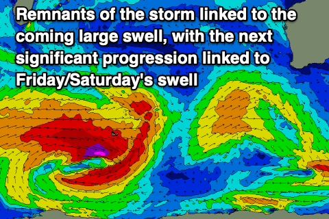
This will be produced by a broad, strong and slow moving frontal progression that’s currently south-east of South Africa, generating an elongated fetch of sever-gale W’ly winds. The progression will stall slightly while weakening and then have a secondary projection towards us through tomorrow and Wednesday, weakening while projecting up and into us on Saturday.
This will unfortunately bring strong but easing SW tending S/SW winds across the South West on Saturday, S/SE to the north early along with 10-12ft+ waves in the South West, 3-4ft across Mandurah and 2-3ft in Perth.
Sunday and Monday are the pick as the remnants of the swell generating system moves east, allowing winds to swing E/SE with large, easing surf.
This might signal the end of our large, active summer so far but we’ll confirm this on Wednesday.