OK weekend, better next week

Western Australian Forecast by Craig Brokensha (issued Wednesday January 8th)
Best Days: Saturday morning in the South West, Tuesday morning, Wednesday morning
Features of the Forecast (tl;dr)
- Small with E winds tomorrow ahead of sea breezes
- Moderate + sized SW groundswell building Fri (peaking later), easing slowly Sat with a reinforcing pulse Sun slowing the easing trend
- Fresh S-S/SW winds Fri, shifting SW through the day
- Light E-E/NE winds in the South West Sat ahead of weak sea breezes, S/SE tending strong SW to the north
- W/SW winds Sun, increasing
- Large W/SW groundswell building later Mon, peaking Tue with S/SE winds to the south, SE to the north ahead of strong sea breezes
- Easing swell Wed with E winds ahead of sea breezes
Recap
There’s been no swell to report on the last two days, with strong afternoon sea breezes kicking up localised levels of windswell.
This week and weekend (Jan 9 - 17)
Tomorrow morning looks clean but small with a minimal increase in mid-period W/SW swell under light to moderate E/SE winds due to provide little waves on the magnets in the South West.

Of more importance is the swell due into Friday, with a healthy low currently forming south-west of us.
A fetch of W/SW gales will stall in our south-western swell window today and this evening before slowly weakening tomorrow.
No major size is expected from this low but the South West should build to 6ft through the afternoon (likely rare bigger one later), with 1-2ft sets in Mandurah and 1-1.5ft waves across Perth.
The slow movement of the low should extend the life of the swell with Saturday due to ease back from 4-6ft in the South West with small to tiny waves to the north.
Sunday will ease further but the trend will remain slow thanks to a reinforcing pulse of mid-period swell generated off the back side of the low due to fill in later Saturday.
The South West should still be 4-5ft or so, tiny to the north.
Looking at the local winds and a trough will bring unfavourable S-S/SW winds across all locations Friday, shifting SW into the afternoon as the swell builds, with Saturday morning being the pick under a light offshore E-E/NE breeze in the South West, less favourable and S/SE to the north.
Sea breezes look relatively weak around Margs, stronger to the north.
W-SW winds will create bumpy conditions Sunday with the reinforcing swell on the ease.
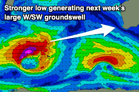
Now, as touched in Monday’s update, a large W/SW due into later Monday, peaking Tuesday is on track, with a strong low currently forming to the south-east of South Africa.
This low is due to generate a fetch of gale to storm-force W/SW winds while projecting east tomorrow, weakening around the Heard Island region Friday but then projecting back up towards us through the weekend while generating weakening gales.
Later Monday’s increase in swell looks mostly mid-period with the larger groundswell due into Tuesday with the South West expected to come in around the 10ft range with 3ft sets across Mandurah, 2-3ft in Perth.
Local S/SE morning winds should be seen in the South West, more SE to the north ahead of sea breezes with great conditions as the swell eases Wednesday. We’ll confirm this on Friday though.