Average period of winds with varying swell pulses

Western Australian Forecast by Craig Brokensha (issued Monday January 6th)
Best Days: Saturday morning in the South West
Features of the Forecast (tl;dr)
- Fading surf tomorrow with S-S/SW winds, freshening
- Small to tiny Wed with fresh S/SE winds ahead of strong S/SW sea breezes
- Moderate + sized SW groundswell building Fri (peaking PM) with S tending fresh S/SW winds
- Easing surf Sat with light SE tending strong S/SW winds
- Small reinforcing SW swell Sun with fresh W/SW winds
- Large W/SW groundswell next Tuesday but with tricky winds
Recap
The swell backed off into Saturday morning, but a new pulse of mid-period swell yesterday provided more size and fun waves across the South West with tiny waves to the north.
This morning is cleaner across exposed breaks as the swell eases back from 3-4ft, tiny to the north.
This week and weekend (Jan 7 - 12)
As touched on last week, the coming outlook is quite slow and nowhere near as active or as favourable wind wise as the last few weeks.
The current swell will continue to ease through tomorrow as winds shift S-S/SW thanks to a weak trough clipping the state.
Wednesday looks no better with no decent swell though with fresh S/SE winds through the morning.
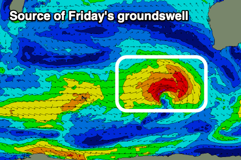
Fresh S/SE-SE winds and no new swell will make Thursday another lay day, while come Friday, a new moderate + sized SW groundswell should be in the water.
This will be produced by a strong but short-lived low firing up to our south-west on Wednesday, with a tight fetch of gale to sever-gale W/SW winds due to produce a quick spike in swell to 5-6ft across the South West, peaking into the afternoon with 1-1.5ft waves to the north.
Unfortunately a trough spawning off the back of the swell producing low will clip us on Friday, bringing S tending S/SW winds.
Saturday should come in cleaner with a light SE breeze but easing surf from 4-5ft in the South West, tiny to the north.

The easing trend will be stalled slightly into Sunday as a long-range mid-period swell fills in, though the remnants of the next swell generating system looks to move in, bringing increasing onshore winds.
The swell generating system will be a strong low traversing the Southern Ocean between South Africa and us, with various fetches of gale to sever-gale W/SW winds due to generate a large W/SW groundswell for next Tuesday.
At this stage the size is up for grabs but we may see surf in the 10ft range across the South West, 2-3ft Mandurah and 2ft+ Perth, but we’ll have a closer look at this Wednesday.