Good run of autumn surf ahead

Western Australian Surf Forecast by Craig Brokensha (issued Friday March 8th)
Best Days: Tomorrow morning protected spots, the South West Sunday morning, Tuesday, Wednesday morning in the South West
Features of the Forecast (tl;dr)
- Mod-large spike of mid-period SW swell tomorrow with fresh S/SE winds ahead of strong S/SW sea breezes
- Easing swell Sun with E/SE-SE winds ahead of sea breezes
- Smaller Mon with gusty SE winds ahead of sea breezes
- Large S/SW groundswell for Tue AM with fresh E/SE winds ahead of later sea breezes
- Easing swell Wed with E/SE-SE winds ahead of sea breezes
Recap
Wednesday's strong pulse of SW swell eased off slowly through yesterday with great conditions through the morning and easing 4-6ft sets in the South West with 1-2ft waves across Perth and Mandurah.
This morning was a touch smaller again with humid, hot weather and variable winds ahead of a strengthening, cooler S/SW change.
This weekend and next week (Mar 9 - 15)

Today's change is linked with a deepening trough come low moving in from the west, with a fetch of strong to near gale-force SW winds due to produce a sizey spike in swell energy for tomorrow morning. The strength of the system has been upgraded, as has the expected size, with surf to 6ft+ due across exposed breaks in the South West, 2ft to possibly 3ft in Mandurah and 2ft across Perth.
Winds will swing back to the S/SE tomorrow morning and be fresh, ahead of strong S/SW sea breezes. This will favour protected spots.
Sunday looks cleaner with moderate E/SE-SE morning winds and easing surf back from 4ft or so in the South West, tiny and 1-1.5ft to the north, if that. Monday will be smaller with fresh SE winds, a lay day for most ahead of our new strong S/SW groundswell Tuesday.
The polar low linked to this swell is currently forming east of the Heard Island region, with an intial fetch of gale to severe-gale W/SW winds due to be piggy-backed by a slower moving fetch of severe-gale SW winds.
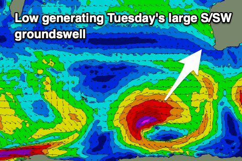
The swell looks good with 8ft+ sets due across the South West when it peaks Tuesday morning, 2-3ft across Mandurah and 2ft in Perth.
Conditions look great for Tuesday morning with offshore E/SE winds and late sea breezes, clean again Wednesday morning but easing back from a smaller 5-6ft or so.
As touched on last update, smaller surf is due into the end of week with more swell due but with wind from later next weekend into the following week. More on this Monday.