Fun swells this week but with windy conditions

Western Australian Surf Forecast by Craig Brokensha (issued Monday January 8th)
Best Days: Protected spots Margs all this week, Perth and Mandurah Wednesday morning
Features of the Forecast (tl;dr)
- Moderate sized mid-period SW swell building tomorrow, peaking later, easing Wed
- Reinforcing, slightly smaller swell for Thu, easing Fri, with a final pulse of less consistent swell filling in Sat, peaking into the PM
- Strong S/SE winds Tue, a little weaker Wed ahead of strong sea breezes
- Gusty S/SE-SE winds Thu/Fri, strong SE Sat AM ahead of strong sea breezes
- Return to S/SE winds Sun and early next week with small surf
Recap
Nice conditions on Saturday with inconsistent 3-4ft sets on the magnets, best on the small wave breaks with flat conditions to the north.
Sunday provided a lift in size as some better, mid-period W/SW swell filled in, with sets to 5-6ft on the magnets with favourable, cross-offshore winds. Mandurah was 1-1.5ft, increasing a little further through the day, similar to Perth.
The swell has held nicely this morning with the metro locations being better and to 1-2ft with clean conditions, 4-5ft in the South West.

Chunky sets building yesterday
This week and weekend (Jan 9 – 14)
With yesterday's swell now easing, we've got some good new mid-period SW energy due to fill in tomorrow, taking its place and peaking through the afternoon, with a secondary stronger pulse of swell for Wednesday and Thursday.
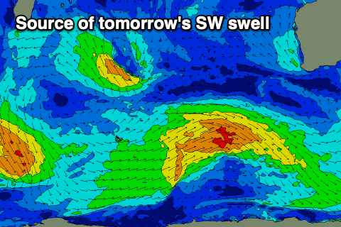
These swells are being generated by an active but generally weak storm track to our south-west with back to back fronts producing fun pulses of swell this week and Saturday.
The first pulse for tomorrow was generated by a fetch of strong W/NW-W/SW winds with the remnants of the storm now weakening south-west of us.
Building surf to 5-6ft is due in the South West tomorrow, 1-2ft in Perth and Mandurah with easing surf from 4-6ft and 1-2ft respectively Wednesday.
A secondary system firing up on the tail of the current should generate a reinforced pulse of mid-period SW swell for later Wednesday and Thursday to 4-5ft+, easing Friday.
One final pulse of less consistent but reinforced SW swell is then due Saturday, generated on the tail of all the activity. This should maintain 4-5ft surf in the South West, tiny to the north before easing Sunday.

Local winds are tricky and will favour protected spots. Tomorrow will see strong winds from the S/SE with even stronger sea breezes, a little weaker but still S/SE into Wednesday, possibly tending SE at times during the morning. Thursday will see similar but stronger S/SE-SE winds, similar Friday but more SE.
Saturday looks cleanest across more exposed breaks but still windy and from the SE, with Sunday seeing winds revert back to the S/SE.
Longer term, early next week is poor with no swell and persistent, strong S/SE-SE winds. More on this Wednesday and hunt the protected options.