Workable surf over the coming days

Western Australian Forecast by Craig Brokensha (issued Wednesday December 27th)
Best Days: Tomorrow morning in the South West, Friday morning in the South West, Saturday morning in the South West, Sunday morning in the South West
Features of the Forecast (tl;dr)
- Fun mid-period S/SW swell tomorrow with strong SE winds (possibly E/SE at times), S/SE into the afternoon (S/SW-SW to the north)
- Inconsistent SW groundswell for Fri, peaking in the PM, easing slowly Sat
- Strong E/SE winds Fri AM, easing ahead of late sea breezes, similar Sat
- Small, reinforcing S/SW swell for Sat PM, easing Sun AM
- SE winds Sun AM
- Small W/SW swell for Tue
- Moderate sized + W/SW swell for next Thu, building, peaking Fri
- E/SE-SE tending S/SW winds
Recap
Poor, windy surf yesterday with onshore winds across all locations and a kick in localised windswell. Today winds have started to improve but the surf is still average, weak and not great at all.
This week and weekend (Dec 28 - 31)
Conditions are due to improve through the end of the week and we should see a mix of mid-period and distant SW groundswell building over the coming days, peaking through Friday, easing slowly into the weekend.
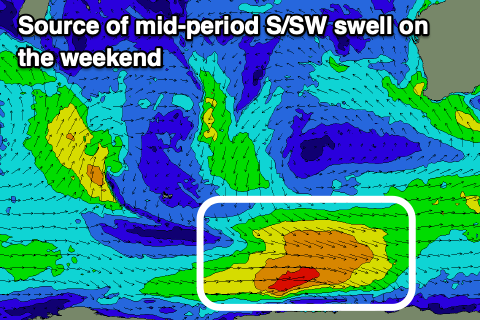
The mid-period energy has been created by healthy polar frontal activity to our south-west, while a distant, strong low near South Africa has generated the groundswell.
The mid-period energy should be in the water with surf to 4ft across the South West, tiny in Perth and Mandurah.
Friday should build to a less consistent but stronger 4-5ft across Margs while Perth and Mandurah remain tiny again and to 1-1.5ft max.
Strong SE winds are due tomorrow morning, possibly tending E/SE for a period during the morning in the South West, tending S/SE-SE into the afternoon. Perth and Mandurah will see strong S/SW-SW sea breezes.
Friday morning looks windy early, with strong E/SE winds that will then back off into the late morning ahead of strong S/SW sea breezes.

Easing surf from the 4ft range is due on Saturday morning under strong E/SE winds, easing ahead of late afternoon sea breezes, smaller Sunday and to 3-4ft with a morning SE breeze. The easing trend will be slowed by a healthy but late morning polar front to our south-southwest today.
Longer term, besides a small pulse of W/SW swell for Tuesday, a better swell looks likely later in the week, generated by a healthy frontal progression firing up to the south of South Africa on Friday.
Moderate sized + surf is likely from this progression along with morning offshores. More on this Friday.