Small swells with windows of morning offshores

Western Australian Surf Forecast by Craig Brokensha (issued Monday October 23rd)
Best Days: Tomorrow in the South West ahead of sea breezes, Saturday morning in the South West, Monday morning week in the South West
Features of the Forecast (tl;dr)
- Small-mod sized mid-period SW swell tomorrow with mod-fresh E tending weaker E/NE winds and late sea breezes
- Fading swell Wed with strong E/NE tending weaker N/NE winds
- Increasing S/SW-SW winds Thu with a weak building swell
- Weak W/SW swell Fri with strong S/SE winds
- Slightly better mid-period swell Sat with E/SE winds ahead of strong sea breezes
- Easing swell Sun with S/SE tending SW winds
- Small-mod sized mid-period S/SW swell Mon with E/SE winds ahead of strong sea breezes
Recap
The surf faded through the weekend with clean conditions and small options on the South West magnets Saturday, tiny to the north. Yesterday was smaller and with strengthening onshore winds.
Today a new mid-period S/SW-S swell has boosted waves heights to 3-4ft across the South West with cross-shore winds, tiny and to 1-1.5ft in Mandurah and Perth.
This week and weekend (Oct 24 - 29)
Today's swell was generated by a trough moving in from the west and this will clear off tomorrow allowing winds to swing offshore along with a better, background mid-period SW swell.
The mid-period swell was generated by a relatively weak polar front and should boost wave heights to 4-5ft on the South West magnets, 1-1.5ft max to the north but with great, moderate to fresh E winds, easing and tending E/NE ahead of late sea breezes.
Wednesday will see stronger E/NE winds feeding into a trough to our west but with small, fading surf. Expect winds to ease while tending N/NE into the afternoon, swinging onshore as the trough moves in through the evening, leaving fresh S/SW-SW winds into Thursday.
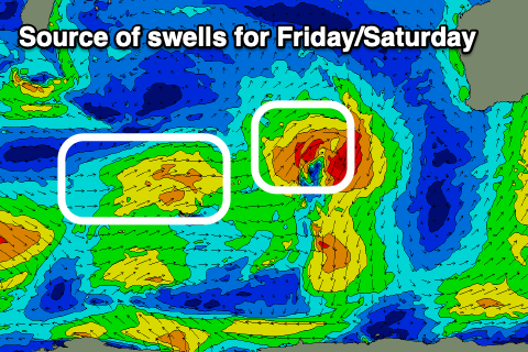
The trough is due to produce a small pulse of weak W/SW swell that's expected to build Thursday and peak Friday but to a weak 3-4ft in the South West, tiny and to 1-1.5ft in the north.
A secondary, slightly better pulse of mid-period swell is due to arrive through Saturday, generated by another weak but slightly broader trough and this should generate surf more to 4-5ft in the South West but remaining in the 1-1.5ft range to the north.
Winds are due to swing S/SE on Friday but be strong, creating generally average conditions while Saturday looks the pick with an E/SE offshore ahead of strong sea breezes.
A trough looks to bring deteriorating conditions on Sunday with easing surf, back offshore from the E/SE again Monday with some new mid-period swell.
Again the size of this swell looks to be insignificant, generated by a strengthening polar front to the south-west of us on the weekend with a pulse to 4ft or so due in the South West, tiny to the north.
Longer term the outlook remains void of any major surf thanks to a large blocking high setting up south-west of us. More on this Wednesday.