Cleaner conditions with smaller surf

Western Australia Surf Forecast by Craig Brokensha (issued Wednesday October 12th)
Best Days: Desperate surfers in the South West tomorrow and Friday mornings, Sunday morning as well, Monday protected spots, Wednesday
Features of the Forecast (tl;dr)
- Small Thu with E/SE tending SW winds
- Small new mid-period SW swell Fri with variable tending W/NW winds
- Easing surf on the weekend with S/SW winds Sat, E/SE tending SW Sun
- Weak increase in SW swell Sun
- New moderate sized SW swell Mon with S/SE tending S/SW winds
- Better SW groundswell for Wed PM with E/SE tending S/SW-SW winds
Recap
Fun waves across Perth yesterday morning with clean conditions and 2ft+ surf, a little raw and lumpy in Mandurah with 2-3ft waves, best in protected spots while the South West remained poor and onshore.
The swell has eased into today leaving smaller 1-2ft waves across Perth, 2ft in Mandurah along with cleaner conditions. The South West was smaller and weaker with cross-shore winds.
This week and next (Oct 13 - 21)
Looking at the end of the week, and we've got cleaner conditions due in the South West but with small, weak swells.
A light E/SE offshore wind is due tomorrow but swell wise, the magnets will be slow and only to 3ft max on the sets. Perth and Mandurah will become tiny.
A new pulse of SW groundswell, spreading off an unfavourably aimed but decent fetch of NW gales is due Friday, boosting wave heights a touch to 3-5ft in the South West, while Perth and Mandurah look to remain tiny.
A trough looks to be lingering in the region, bringing dicey winds but they'll likely be variable in the morning before shifting W/NW through the day. This looks like a fun day for those with low expectations.
The swell is due to ease back through Saturday and the trough unfortunately looks to bring weak S/SW winds to the Margaret River region. An offshore wind should kick back in again Sunday along with a small pulse of new mid-period SW swell.
Size wise it looks to be 3-4ft max but with the light winds, it'll be OK on the swell magnets.
 A secondary, small low will produce a slightly bigger, weak swell for Monday but only to 4-6ft in the South West and 1-2ft in Mandurah, tiny in Perth. Conditions look OK with a morning S/SE breeze, but again it won't be ideal.
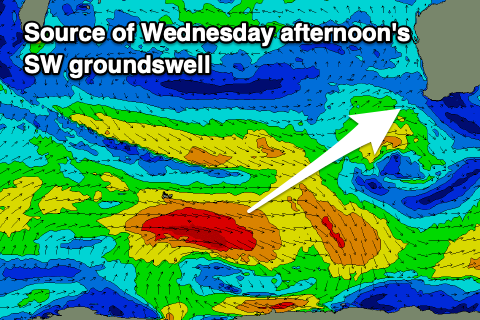
Looking at the stronger polar low that was possibly on the cards, this is now looking weaker with a fetch of polar W/NW and W/SW gales due to generate a fun, moderate sized pulse of SW groundswell.
The swell should fill in Wednesday and reach 6ft+ in the South West into the afternoon, 2ft+ across Mandurah and 2ft in Perth. Conditions look clean and great with offshore E/SE winds and S/SW-SW sea breezes, average into Thursday as another front pushes in, bringing S/SW winds.
Longer term the cold front bringing Thursday's change could deliver a larger SW groundswell into the end of the week/weekend but more on this Friday.