Average, windy weekend, better early next week

Western Australia Surf Forecast by Craig Brokensha (issued Friday September 30th)
Best Days: Monday all locations, Tuesday morning in the South West, Thursday morning Perth and Mandurah, Friday
Features of the Forecast (tl;dr)
- Small, inconsistent SW groundswell arriving later today, peaking tomorrow with strong S/SE winds, increasing further
- Easing SW swell Sun with gusty SE winds, strengthening from the S/SE into the PM
- New moderate sized W/SW swell Mon with E/SE winds ahead of sea breezes from mid-afternoon
- Easing W/SW swell Tue with fresh E/NE tending N winds
- Poor Wed with strong SW tending S/SW winds (possibly NW at dawn)
- Building windswell Wed PM and further Thu with fresh S/SW winds (S/SE early Perth and Mandurah)
- Large W/SW groundswell for later Wed but more so Thur, easing slowly Fri
- S tending SW winds Fri, E/SE Perth and Mandurah
Recap
A continuation of good surf across all locations yesterday with Monday afternoon's reinforcing SW groundswell easing back from 6ft+ in the South West, 2-3ft in Mandurah and 2ft across Perth. Sea breezes kicked in late morning, creating average surf into the afternoon.
Today the swell is a touch smaller but steadying with the arrival of a mid-period SW swell. Sets are still a good 6ft in the South West, 2ft across Mandurah but back to 1-1.5ft in Perth. Winds look to strengthen from the S/SE in the South West this afternoon, shifting S/SW further north so make the most of this morning.

Fun sets yesterday early PM
This weekend and next week (Oct 1 - 7)
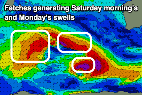
This afternoon a new pulse of small SW groundswell is due to arrive in the South West, peaking tomorrow morning. This was generated by a trick fetch of severe-gale W/NW tending NW winds, and we'll see the swell coming in at 4-5ft across the South West magnets, tiny and to 1-1.5ft across Mandurah and 1ft in Perth.
Winds won't be ideal tomorrow though as a trough brings a gusty S/SE change this evening, leaving strong S/SE breezes tomorrow morning that will increase further into the afternoon. Further north winds look more moderate in strength.
 The swell should slowly ease through Sunday as winds shift more SE, gusty in nature before reverting back to the S/SE into the afternoon.
At this stage Monday looks fun with a pulse of new mid-period W/SW swell as winds continue to improve, swinging E/SE. The source of the W/SW energy was a healthy fetch of gales on the backside of the progression generating later today and early tomorrow's swell. Sets to a good 5-6ft are due in the South West, 2ft in Mandurah and Perth on the sets. Sea breezes are likely but only from mid-afternoon.
The swell will start to ease into Monday afternoon, smaller Tuesday and best in the South West with winds out of the E/NE, shifting more N'ly through the day.
Conditions will start to deteriorate Wednesday as a deepening mid-latitude trough pushes in from the west, bringing a persistent run of offshore winds later week as it forms into a slow moving low south of us.
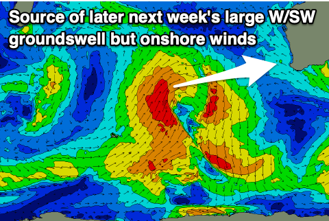 The earlier stages of the trough will project a good fetch of SW gales through our swell window, generating a moderate-large W/SW groundswell that will build later Wednesday afternoon and peak Thursday.
Unfortunately winds will be poor and they're be a localised windswell in the mix with strong SW-S/SW winds due Wednesday, fresh S/SW on Thursday. Perth and Mandurah should see early S/SE winds on Thursday and size wise we should be seeing 8ft sets across the South West, 2-3ft waves in Mandurah and Perth.
Lighter S'ly winds may be seen on Friday morning in the South West as the swell eases but we'll have a closer look at this on Monday. Perth and Mandurah will be nice and clean with easing sets from 2-3ft.
Longer term the outlook goes a little quiet, but check back here on Monday for the latest. Have a great weekend!