Good to great tomorrow and early Friday

Western Australia Surf Forecast by Craig Brokensha (issued Wednesday September 21st)
Best Days: Tomorrow, Friday morning, Sunday morning Perth and Mandurah, Monday morning, Tuesday morning, Wednesday morning
Features of the Forecast (tl;dr)
- Large SW groundswell for tomorrow with light E/SE winds and weak sea breezes
- Easing SW swell Fri with early E/NE winds, tending N/NW late morning and strengthening
- Poor surf Sat with strong S/SW-S winds
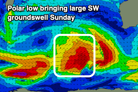
- Large new SW groundswell Sun with fresh SW winds (lighter NE early Perth and Mandurah)
- Easing swell Mon with E/NE tending W/NW winds
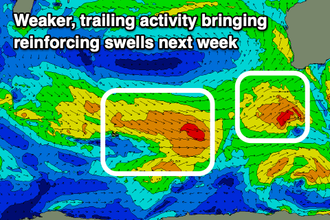
- Reinforcing moderate sized SW energy Tue and Wed with light, local offshore winds
Recap
Poor surf across Margs and Mandurah yesterday with the increase in size seen Monday afternoon dropping back a touch. Perth saw the forecast early period of NE winds, though deteriorated quickly from mid-morning.
Today a slightly stronger pulse of SW swell has filled in across the South West as onshore winds persist, poor across Mandurah and decent early in Perth again but now onshore.
This week and weekend (Sep 20 - 25)
We've got much better waves and a lot more options opening up surf wise over the coming days as the strong frontal progression linked to our onshore winds and large surf pushes east.
 This will allow a high to move in, swinging winds offshore from the E/SE tomorrow morning across Margs, SE in Perth and Mandurah along with the largest pulse of SW groundswell.
The polar front linked to this swell is currently weakening to our south-west and we'll see it arrive tomorrow, peaking to 10-12ft in the South West, 4ft across Mandurah on the sets and 3ft in Perth. Sea breezes are only expected to be weak into the afternoon, creating a good to excellent day of waves.
The swell will ease into Friday and the window of clean conditions will be smaller, E/NE at dawn but deteriorating from late morning as winds shift N/NW and then strengthen ahead of the next approaching frontal system.
This front will form as a polar system around the Heard Island region today, with a fetch of gale to sub-gale-force W/SW winds due to project east and then north-east. The front will weaken on approach Saturday, bringing strong S/SW-S winds to all locations with the swell due to arrive a day later on Sunday.
 We should see good 8-10ft surf across the South West, 2-3ft in Mandurah and 2ft in Perth Sunday when it peaks but with fresh, lingering SW winds (lighter and NE through the morning in Perth and Mandurah).
Monday looks to become cleaner across the South West with variable offshore winds and easing surf from 6-8ft, 2ft+ and 1-2ft respectively across Margs, Mandurah and Perth.
Tuesday and Wednesday look fun with a reinforcing pulse of mid-period SW energy and local offshore winds (a touch dicey for the South West Tuesday morning). We'll have a closer look at this Friday.