Smaller end to the week, very large into the weekend

Western Australia Surf Forecast by Craig Brokensha (issued Wednesday August 24th)
Best Days: Margs tomorrow morning, Sunday, Monday, Tuesday, Wednesday, Thursday
Features of the Forecast (tl;dr)
- Small, mid-period SW swell tomorrow, easing Fri with E/NE tending variable N winds Thu, SE tending SW Fri
- Strong SW tending S/SW winds Sat with a mix of new, building swells
- XL, long-period SW groundswell filling in Sun, peaking in the PM with S/SE tending S/SW winds in the South West, E/SE-SE tending S/SW further north
- Large, easing swell Mon with E/NE tending variable winds, smaller Tue with E tending variable winds
- Large, reinforcing SW groundswell arriving later Wed, easing Thu
- E tending variable winds both Wed and Thu
Recap
Great surf yesterday across the South West with easing 4-6ft sets with super clean conditions, 2ft in Mandurah and 1-2ft across Perth. Today the swell is smaller again with stronger offshore winds, best across the South West magnets with 1-2ft leftovers in Mandurah and 1-1.5ft sets in Perth.
This week and weekend (Aug 25 - 28)
Looking at the coming days, and Perth and Mandurah are due to remain tiny as a small, mid-period SW swell spreads up and into the South West tomorrow, easing through Friday.
The source of this swell is a great but poorly aimed fetch of strong to gale-force W/NW winds moving through our swell window, with 4ft sets due to spread radially up and into us tomorrow, easing from a similar size Friday morning.
Winds should ease and be favourable with a light to moderate E/NE breeze tomorrow morning, shifting variable into the afternoon, with SE tending S/SW winds on Friday.
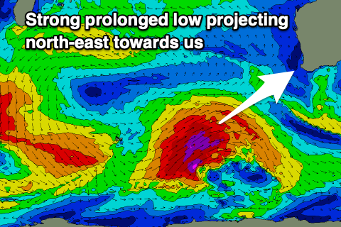 Moving into the weekend, winds are expected to strengthen from the SW tending S/SW thanks to a significant but weakening polar low pushing up and across us.
This low has started its life to the south-east of South Africa, with an off axis fetch of gale to severe-gale W/NW winds due to give way to a stronger fetch of severe-gale to storm-force W/SW winds around the Heard Island region tomorrow, then projecting north-east during Friday, weakening on approach Saturday.
We should see a large SW groundswell from the pre-frontal W/NW fetch of gales arriving later Saturday but with those poor winds, ahead of the XL long-period groundswell Sunday, peaking into the afternoon.
Sets to 12-15ft are due across the South West magnets into the afternoon, 3-4ft in Mandurah and 3ft across Perth and morning winds look favourable with offshore E/SE-SE breezes in Perth and Mandurah, light S/SE across Margs with weak S/SW-SW sea breezes.
Monday still looks the pick with easing sets from 10ft+ in the South West, 3ft across Mandurah and 2ft+ in Perth with a light E/NE offshore and weak sea breezes.
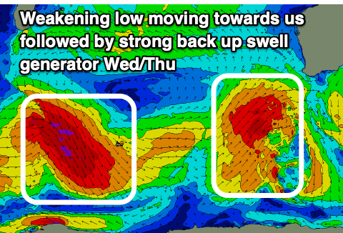 Tuesday looks clean again with a bit less size, though later in the day a new SW groundswell is due, generated by gale-force NW tending W/NW winds following the strong low Friday through the weekend.
This swell looks large in size, building back later Wednesday to 6ft to possibly 8ft and easing from a similar size Thursday morning in the South West, 2ft+ in Mandurah and 1-2ft in Perth. Conditions should remain favourable and clean with morning offshore breezes, variable into the afternoons but we'll have a closer look at this Friday.
Longer term a few fun follow up swells are on the cards, but we'll look at this in more detail Friday.