Good surf tomorrow, average until next week

Western Australia Surf Forecast by Craig Brokensha (issued Monday June 7th)
Best Days: Tomorrow, selected spots in the South West Wednesday morning, next Monday and Tuesday
Features of the Forecast (tl;dr)
- Good mid-period SW swell peaking tomorrow AM with fresh to strong E/NE winds, easing Wed with strong E/NE tending NE winds
- Weak mix of windswells Thu with fresh W/NW tending W/SW winds
- Large W/SW groundswell for Mon with variable winds
Recap
Onshore winds and a slowly increasing swell in the South West, peaking yesterday to 4-6ft. Perth and Mandurah saw 1-2ft waves Saturday morning, cleanest in Perth with a bit more energy yesterday as early onshore winds in Mandurah turned offshore through the morning, cleanest in Perth again.
This morning winds improved slightly across Margs with surf to 4-6ft, 2ft and cleaner in Perth and Mandurah.
This week and weekend (Jun 8 - 13)
Into this afternoon we've got our larger, mid-period SW swell due to fill in, with a peak still expected tomorrow.
The source of this swell was a good, though not overly strong polar front projecting a fetch of strong to gale-force winds from under the Heard Island region, up towards us over the weekend. The low/frontal system is now under us, pushing towards the Bight, with the swell due to peak to 6ft+ across the South West tomorrow morning, 2ft+ in Mandurah and 2ft across Perth.
The main positive for this swell is the local winds, with a high due to move in quickly overnight tonight, shifting winds around to the E/NE tomorrow, fresh to strong in the South West, strong further north and holding all day as a mid-latitude low deepens to our west.
Stronger E/NE tending NE winds are due on Wednesday as the swell fades from the S/SW, favouring selected locations in the South West, tiny to the north. Thursday will then be poor as the low pushes east, bringing strong W/NW tending W/SW winds.
This low looks poor for swell generation with the strongest winds being on its eastern flank and out of the N'th, with not much behind it out of the W-SW.
Background levels of inconsistent and small groundswell are due into Friday as winds improve for Perth and Mandurah, light NE through the morning but W/NW across the South West.
 A new ridge of high pressure is due to fill in on the weekend, with a slight improvement in winds across the South West, swinging back onshore Sunday as another cold front pushes through. Swell wise Perth and Mandurah look tiny with inconsistent 3-4ft sets in the South West.
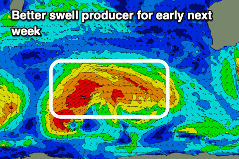
This cold front should bring some better swell behind it with a good fetch of pre-frontal W'ly gales due to be followed by post-frontal W/SW gales, producing a large W/SW groundswell for Monday.
Size wise we're looking at surf in the 10ft range across the South West, 3ft+ in Mandurah and 2-3ft across Perth and with light winds. Check back here on Wednesday and Friday for an update on how this swell is tracking though.