Great surf over the coming days

Western Australia Surf Forecast by Craig Brokensha (issued Wednesday April 21st)
Best Days: This afternoon, tomorrow, Friday, dawn Saturday in the South West, Sunday morning in the South West, Tuesday morning
Features of the Forecast (tl;dr)
- Large S/SW groundswell for tomorrow with fresh E-E/NE winds, variable ahead of sea breezes, easing Fri with moderate E-E/NE winds, variable ahead of sea breezes
- New, inconsistent SW groundswell for Sat PM, easing Sun AM with light E winds
- Run of mid-period W/SW swells from Tue-Fri next week
Recap
Fun waves across the South West the last two days, clean and to 3-4ft with tiny 1-1.5ft waves in Mandurah, tiny in Perth. A new swell is starting to show across the South West now and we should see it building to 6ft+ by dark as winds reman favourable – tending S/SE-SE mid-late this afternoon.

New swell on the build
This week and weekend (Apr 17 – 23)
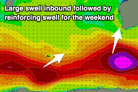
This afternoon's building SW groundswell was generated by the initial stages of a 'bombing' low forming south-west of us, with a fetch of severe-gale to storm-force W/SW winds moving through our south-western and then southern swell windows.
The largest increase in size out of the S/SW from the strongest part of the low is due to fill in tomorrow with surf to 8ft+ due across the South West, 2-3ft in Mandurah and 2ft+ in Perth.
 Conditions look great tomorrow with a fresh E'ly offshore, tending E/NE during the morning and then variable early afternoon ahead of late sea breezes.
Friday should still offer some good size owing to trailing polar activity behind the main low. Size wise the South West should ease back from 6ft+ on the swell magnets, 2ft in Perth and Mandurah. Winds will remain favourable and be moderate out of the E-E/NE, tending variable again early afternoon ahead of sea breezes.
An approaching trough will see winds swing from the NE early Saturday to the N/NW with a further drop in size.
Into the afternoon some new, inconsistent long-period SW groundswell is due to fill in, though the source of this isn't overly significant. A drawn out and patchy fetch of pre-frontal W/NW gales west of Heard Island will produce the swell, with a fun kick in size to 4-5ft due in the South West through the afternoon, 1-1.5ft in Mandurah and Perth.
A drop in energy is expected Sunday from a similar size but with light E'ly offshore winds ahead of sea breezes.
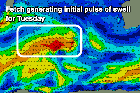 Longer-term a run of mid-period W/SW swell energy is expected from Tuesday through most of next week, generated by slow moving frontal progression. The strongest and most distant of the storms will project a short-lived fetch of W/SW gales towards us over the coming days, followed by mixed fetches of weaker W/SW winds.
Size wise pulses of swell between 4-6ft are due in the South West, 2ft across Mandurah and Perth but as the progression moves towards us we'll see winds swing onshore. Tuesday and Wednesday mornings look to see variable winds, likely more onshore Thursday/Friday, but we'll have a closer look at this Friday.