Best late week, fun weekend

Western Australia Surf Forecast by Craig Brokensha (issued Monday March 29th)
Best Days: Wednesday morning most locations (keen in the South West), Thursday morning all locations, Saturday in the South West, Sunday morning all locations, Monday morning South West magnets
Features of the Forecast (tl;dr)
- Building W/SW swell energy tomorrow, holding Wed, easing slowly Thu
- Light winds over the coming mornings, cleanest Thu with a fresh E/SE offshore
- Fun, mid-period S/SW swell building Sat PM, easing Sun with morning offshore winds
Recap
Nothing to surf Saturday, while yesterday provided a little spike in swell and fun waves for the keen across the South West. Today this swell has held and conditions have been good all morning.
This week and next (Mar 30 – Apr 9)
We'll finally see a bit more size showing across the state over the coming days as a mid-period W/SW swell fills in, with various ebbs and pulses owing to the slow moving frontal progression linked to it.
Various fetches of relatively weak, strong to gale-force winds have been projected towards us since last Friday and we should see the South West varying in size from 4-6ft from tomorrow afternoon through Thursday morning, 2-3ft in Mandurah and 2ft+ across Perth.
Looking at the winds, and tomorrow morning as the first pulse builds we'll see a variable breeze in the South West, light N/NE further north and swinging onshore during the day.
Wednesday looks cleanest around Perth and Mandurah with a light S/SE breeze, likely lingering onshore across the South West, but possibly variable, providing lumpy workable waves.
A trough should bring a change in winds Thursday with an evening S'ly on Wednesday due to swing SE and E/SE through the morning, creating great conditions as the swell eases.
 Friday looks less favourable as a weakening cold front pushing up from the south-west reverts winds back to the S/SE with smaller, fading surf.
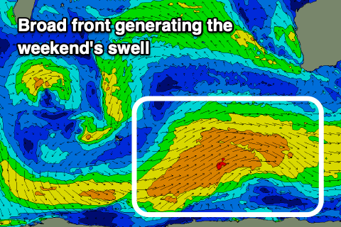
Now, as touched on last update, a polar frontal progression is due to fire up through our southern swell window though this week and weekend, generating some new mid-period S/SW swell for the weekend.
The fronts won't be overly strong and size wise we should see a late increase in size Saturday across the South West, not arriving north until Sunday.
Sets to 4-6ft are due late in the day across the South West, similar Sunday morning with 2ft sets in Mandurah and 1-2ft waves across Perth. Conditions look great each morning with offshore winds, giving into afternoon sea breezes.
Longer term there are a couple of new swells sources for mid-late next week but the models are still struggling to resolve them. More on this in the coming updates.