Get stuck into the coming swells

Western Australia Surf Forecast by Craig Brokensha (issued Wednesday March 17th)
Best Days: Keen surfers Friday, beaches Saturday morning, keen surfers Tuesday and Wednesday mornings
Features of the Forecast (tl;dr)
- Better mid-period SW swell for late today, peaking tomorrow with moderate S/SE-SE morning winds, dropping a touch Fri with morning E/SE tending E/NE winds ahead of sea breezes
- Stronger W/SW swell for Sun with light E/SE-E/NE winds ahead of sea breezes, deteriorating Mon with a trough and strengthening from the S
- Nothing significant to follow
Recap
The surf came up a touch yesterday with clean, fun 3ft waves across the South West magnets, tiny to flat to the north.
This morning the swell seems to have dropped a touch and with funky winds owing to a weak trough moving through. Perth and Mandurah have remained tiny.
This week and next (Mar 18 - 26)
With the weakest and smallest swell out of the way we've got some better energy due to end off the week, with an even better swell for the weekend.
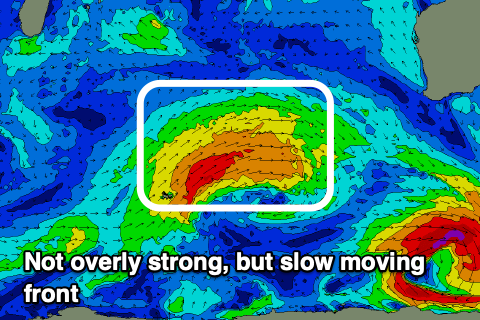
Later today but more so tomorrow a new, mid-period W/SW swell should fill in, generated by a favourably tracking but relatively weak mid-latitude front earlier this week. The swell should come in at a fun 4-5ft+ across the South West with 1-1.5ft sets further north, with a slightly smaller reinforcing swell for Friday.
This will see the size drop a touch Friday to 4-5ft, tiny to the north.
 Winds look generally S/SE tomorrow morning, tending SE at times ahead of sea breezes, with much better E/SE tending E/NE winds on Friday ahead of sea breezes.
Saturday should be clean again with a light E/NE offshore but a little less swell.
Moving into Sunday and our better, moderate-large W/SW groundswell is on track, with a broad, slow moving and favourably tracking front due to develop around Heard Island and project towards us today through Friday.
A fetch of strong to near gale-force W/SW winds will be generated, with the swell being more positioned towards mid-period energy rather than groundswell, but still we should see consistent and fun 6ft to possibly 8ft surf across the South West magnets through Sunday possibly a touch undersized early) with 2ft sets in Perth and Mandurah.
 Winds look favourable and light out of the E/SE across the South West, E/NE further north ahead of sea breezes, with E/NE winds early in Perth Monday, strengthening S tending S/SW across the South West as a trough moves in.
Tuesday looks unfavourable with lingering S/SE winds, cleaner Wednesday but the swell will be small and on the way out (2-3ft max in the South West).
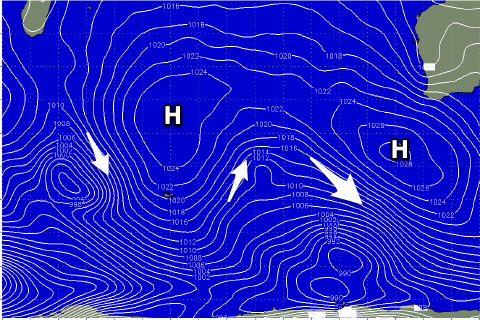
Longer term the outlook still remains void of any major storms with a blocking setup encompassing the entire Indian Ocean (right), so make the most of the coming swells.