Large, long-period swell on track

Western Australia Surf Forecast by Craig Brokensha (issued Wednesday February 24th)
Best Days: Friday afternoon protected spots, Saturday protected spots, Sunday morning protected spots, Mon AM swell magnets in the South West
Features of the Forecast (tl;dr)
- Large, long-period SW groundswell building strongly Fri PM with strong S/SE winds, peaking Sat Am with strong SE morning winds
- Easing surf Sun with fresh morning SE winds, fading Mon with a fresh morning E/SE breeze
Recap
Easing surf across the state yesterday, back from a clean 4-5ft in the South West at dawn, 1-2ft further north.
Today the swell has bottomed out with less favourable conditions across Mandurah.
This week and weekend (Feb 25 - 28)
The coming two days will remain void of any major surf until we see a large, long-period SW groundswell starting to kick in Friday afternoon, peaking Saturday morning.
We've got satellite confirmation of a great, initial fetch of storm-force W'ly tending W/NW winds as the low 'bombed' around the Heard Island region yesterday. This 'bombing' low did so as Tropical Cyclone Guambe was absorbed into the westerly storm track (from a position between Madagascar and South Africa), bringing an injection of warm, moist air to an unstable, cold-core low.
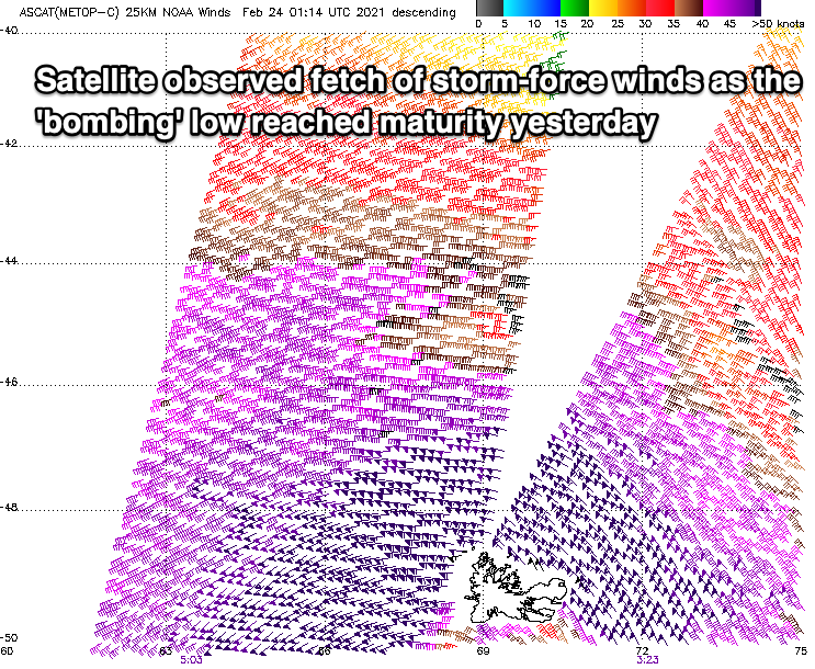
Since yesterday we've seen the low slowly tracking east-southeast while continuing to generate severe-gale to storm-force W/SW-W/NW winds through our south-western swell window. The low will continue to weaken slowly while moving through our southern swell window tomorrow before pushing too far east into the evening.
A large, long-period and inconsistent SW groundswell should be seen, with the initial burst of storm-force W'ly winds yesterday sitting more favourably in Perth and Mandurah's swell window.
An increase in size should be seen Friday afternoon across all locations, with a fairly rapid spike in size across the South West to 8ft+ due by close of play, 2-3ft in Mandurah and 2ft+ in Perth.
Saturday morning should reveal the peak in size with 10ft to possibly 12ft sets in the South West, 3ft in Mandurah on the sets and 2ft to near 3ft in Perth.
Winds on Friday afternoon will favour protected spots in the South West and Mandurah, strong from the S/SE, S-S/SW in Perth. Saturday looks to still see fresh to strong SE winds in the morning, favouring protected spots, similar Sunday as the swell eases.
Better offshore E/SE winds are due on Monday with the surf easing back from 3-4ft max in the South West, tiny to the north.
As touched on last update, following the large groundswell, there's nothing too significant on the cards at all. A tropical cyclone that's forecast to develop in the Indian Ocean doesn't hold any swell potential at this stage, but more on this Friday.