Stormy, large surf tomorrow, XL swell to follow

Western Australia Surf Forecast by Craig Brokensha (issued Wednesday February 17th)
Best Days: Friday morning, Saturday morning in the South West, Sunday, Monday morning
Features of the Forecast (tl;dr)
- Large mix of swells tomorrow with strong to gale-force W/SW winds, easing and tending S/SW, easing Fri with morning SE winds, smaller Sat with a morning SE breeze
- XL SW groundswell for Sun AM with morning SW winds, easing Mon with morning SE winds
Recap
A drop in swell yesterday with OK conditions for the keen in protected spots, easing from around 6ft in the South West, 2ft in Mandurah and a bumpy 1-2ft across Perth.
Today we've seen our new W/SW groundswell starting to fill in across the South West with nice, clean conditions and sets to 6ft+, with more on the way. We should see surf reaching 8ft+ at least with 2-3ft sets in Mandurah and 2ft across Perth but with a shift in winds to the west.
This week and weekend (Feb 18 - 21)
Today's building W/SW groundswell is due to peak tomorrow morning to 8-10ft+ across the South West, 3ft in Mandurah and 2-3ft across Perth, but with the current trend we could see sets hitting this size by dark.
In the mix will also be localised, mid-period energy from the remnants of the swell producing storm, projecting gales into us during the day. Larger 3-4ft waves are then due in Mandurah, with 3ft+ sets across Perth. With this conditions will be poor with strong to gale-force W/SW winds, easing and tending S/SW through the afternoon.
Winds should swing SE Friday morning with a mix of easing groundswell and mid-period swell, dropping from 6ft to possibly 8ft in the South West, 2-3ft in Mandurah and 2ft+ across Perth.
Winds now look SE Saturday morning as the swell continues to drop in size and power.
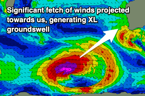 Of greater significance is the XL, long-period SW groundswell due Sunday across the state. This is being generated by a 'bombing' low that formed around the Heard Island region last night and today. A 'bombing' low is one which drops 24hPa or more in central pressure over a 24hr period, and this is easily occurring, with the low bottoming out at 927hPa this evening.
With this, a great fetch of storm-force W/SW winds projected through our medium-range window, with the low due to weaken slowly while projecting east-northeast towards us, continuing to generate severe-gale to gale-force W/SW winds.
Size wise, 12-15ft+ surf is still due across the South West magnets Sunday morning, 4ft around Mandurah and 3ft in Perth along with moderate to fresh SE winds and afternoon sea breezes.
Winds look similar, if not a touch more east of south-east as the groundswell eases, dropping from 6-8ft, 2-3ft and 2ft respectively.
Following these large swells the outlook is quieter so make the most of them!