Windows of fun waves for the weekend, large swells next week

Western Australia Surf Forecast by Craig Brokensha (issued Friday February 12th)
Best Days: Tomorrow, Sunday (Margs only), Monday and Tuesday mornings Margs and Mandurah, late Thursday, Friday morning
Features of the Forecast (tl;dr)
- New S/SW swell filling in Sat with morning E/SE winds, easing Sun with similar morning E/SE winds
- Mix of inconsistent SW groundswell and mid-period SW swell building Mon with morning SE winds, easing Tue with morning S/SE winds
- Large W/SW groundswell for Thu but with strong to gale-force W tending S/SW winds, easing Fri with morning S/SE winds
- Secondary large SW groundswell for next Sun
Recap
Wednesday afternoon's kick in S/SW swell eased back from 4-6ft across the South West yesterday morning with better, though lumpy conditions for the keen, much straighter and cleaner today but back to 3ft. Mandurah was a fun 2ft yesterday (1-2ft Perth), tiny today.
This weekend and next week (Feb 13 - 19)
We should see the surf start to build again through tomorrow, peaking from midday into the afternoon. This will be in the form of a new S/SW groundswell, generating by a good fetch of W/SW gales pushing through our swell window earlier this week.
Sets should reach 4-5ft+ through the day in the South West, a bit smaller early morning, with sets reaching 1-2ft across Mandurah into the afternoon, tiny in Perth. Conditions look good with an offshore E/SE breeze, giving into afternoon sea breezes.
A drop in size is due Sunday along with favourable E/SE morning offshore winds again.
Moving into Monday and the mix of inconsistent, long-period SW groundswell and more consistent mid-period energy are on track, with both due to build through Monday and peak later in the afternoon/evening.
The long-period energy was generated by a strong, distant polar low firing up under South Africa, while the mid-period energy was generated by the remnants of the low, continuing east but in a much weaker form.
The long-period energy should be around in the morning and winds look favourable and out of the SE, tending S/SE ahead of sea breezes with the surf building to 5-6ft late in the day, 1-2ft across Mandurah and tiny in Perth. At the peak of the swell we may see the odd bigger cleaner up across selected breaks in the South West, but expect surf to be mostly around the size outlined above.
 The swell should ease from a similar size Tuesday but with moderate S/SE winds, giving into afternoon sea breezes.
Conditions will deteriorate from Wednesday as a significant though weakening storm projects up from the west-southwest towards us, swinging winds from the S'th to W during Wednesday as the swell continues to ease.
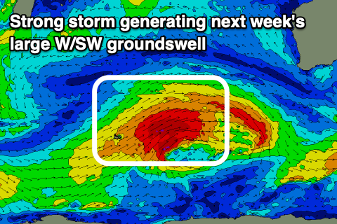
Looking at the storm first and foremost, it'll develop just west of the Heard Island region Sunday, then generating a fetch of severe-gale to storm-force W/SW winds while tracking east-northeast towards us Monday, weakening and stalling Tuesday. Unfortunately this stalling nature will see a trough forming, then a mid-latitude low, pushing in when the swell is due on Thursday, bringing strong to gale-force W tending S/SW winds.
 Size wise, the groundswell will be large and long-period, coming in at 10-12ft across the South West, 3ft+ in Mandurah and 2-3ft in Perth. Winds will improve slightly Friday and tend S/SE as the swell eases, but protected spots will be the only real options.
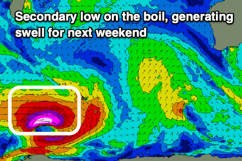
A secondary, large, long-period SW groundswell is on the cards for Sunday as a polar low fires up west of the Heard Island region early-mid next week. Winds look S/SE-S/SW again, but we'll review this Monday. Have a great weekend!