OK end to the week, workable weekend

Western Australia Surf Forecast by Craig Brokensha (issued Wednesday February 10th)
Best Days: Tomorrow morning Margs and Mandurah, Friday morning Margs, Saturday morning Margs, Sunday morning Margs and Mandurah, Tuesday morning protected spots
Features of the Forecast (tl;dr)
- Building mid-period S/SW swell this afternoon, easing tomorrow with light to moderate SE winds in the AM, smaller Fri with morning E/SE winds
- New S/SW swell filling in Sat with morning E/SE winds, easing Sun with stronger morning SE winds
- Mix of inconsistent SW groundswell and mid-period SW swell building Mon, easing Tue with morning S/SE winds
- Larger swells late next week
Recap
Lighter winds around Perth and Mandurah with a weak, smaller, leftover 1-2ft wave for the keen, onshore and poor in the South West.
Today we've still got windy conditions on the coast and a new mid-period S/SW swell is due into this afternoon.
This week and next (Feb 11 - 19)
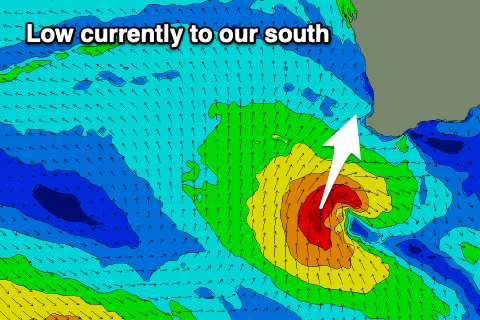 The swell due into this afternoon from the tropical low, come mid-latitude low that's currently stalling south-southwest of us is now looking a little stronger.
The low is stalling a little longer than forecast Monday, with a fetch of strong to gale-force S/SW winds being aimed towards us.
This should generate a kick in size this afternoon to 5-6ft in the South West, 2ft late in Mandurah and 1-1.5ft across Perth.
The swell should then ease tomorrow from 4-5ft+, 2ft and 1-1.5ft respectively and winds will improve, swinging SE across most locations through the morning ahead of sea breezes.
Better offshore E/SE winds are due Friday morning but the swell will be small and weak. Try the South West swell magnets.
Our new S/SW groundswell for Saturday is on track, with it being generated today and tomorrow by a polar front and burst of W/SW gales through our southern swell window.
Size wise, we should see the swell building to 4-5ft+ across the South West by late morning, 1-2ft in Mandurah into the afternoon and tiny across Perth. E/SE offshore winds will create clean conditions again ahead of sea breezes, smaller Sunday with a stronger morning SE breeze.
Moving into next week and our mix of very inconsistent, long-period SW groundswell and more consistent mid-period SW swell for Monday afternoon and Tuesday are still on track.
The long-range energy is being generated by a strong polar low that's formed south of South Africa, with a great fetch of storm-force W/SW winds being projected east through our far swell window. The low will weaken over the coming days, with the remnants continuing east, generating a broad fetch of strong W'ly winds across the Heard Island region, and travelling further south-west of us.
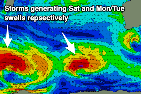 This will generate the mid-period energy with both building through Monday and reaching 5-6ft late in the afternoon across the South West, 2ft in Mandurah and tiny in Perth.
Tuesday looks similar in size, if not more 4-6ft across the South West and 1-2ft in Mandurah, easing through the day and smaller Wednesday.
Unfortunately winds will start to deteriorate on Monday as a weak polar front clips the state with S/SE tending SW winds, similar Tuesday, limiting the best waves to protected spots.
Longer term we're set to see a flurry of stronger frontal systems firing up towards us through mid-late next week under the influence of the Long Wave Trough, but we'll have a closer look at this Friday and next week.