Slow period and a tricky one to pick the eyes out of

Western Australia Surf Forecast by Craig Brokensha (issued Monday 7th December)
Best Days: South West swell magnets tomorrow, mid-late morning Thursday all locations, Friday morning in the South West
Recap
An average to poor weekend of surf with no decent size or quality swell across the state and cross-shore winds. Mandurah faired best Saturday with slightly cleaner and better conditions for Sunday as the swell faded.
This morning the South West was cleaner but only small and surfable at the small wave spots, tiny to the north.
This week and weekend (Dec 8 - 13)
As touched on the last couple of updates, the coming forecast period is fairly slow surf wise, with a positive Southern Annular Mode (SAM) episode keeping the westerly storm track contracted to the pole as well as being weaker in strength.
There are some fun swells for the South West to try and tease out though with generally favourable winds.
Tomorrow looks on the small side again, with a weak, mid-period swell likely to offer 3ft+ waves on the swell magnets in the South West, tiny elsewhere.
Winds will be fresh from the E, easing through the day ahead of strong sea breezes.
Into Wednesday a surface trough drifting inland will bring poor and strong S/SE-S winds to all locations with some windswell due on the Mandurah and Perth coasts, cleaning up into Thursday morning as winds shift back to the E through the late morning. Early still looks wind affected with strong S/SE winds, tending SE while easing.
A new, inconsistent SW groundswell should be in the water later Wednesday and more so Thursday, generated by a broad, slow moving though not overly strong low that was west of Heard Island late last week.
Multiple patchy fetches of strong to gale-force W-W/NW winds generated the swell, and this should produce some OK sets with 3-5ft waves on the South West magnets Thursday, easing Friday. Perth and Mandurah will see the swell mixed with the easing S/SW windswell and surf to 1-2ft.
The swell will ease Friday and winds look a little funky, variable in the morning ahead of sea breezes.
Moving into the weekend it looks like a trough will bring onshore winds Saturday as a small, new S/SW groundswell fills in. The swell should peak Sunday but winds may still be out of the S/SW, creating poor conditions.
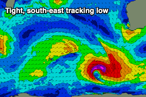 The source of the groundswell is a small, tight low forming late in our swell window and tracking south-east. This isn't ideal at all and will put a cap on the expected size and consistency with the South West due to come in around maybe 3-5ft in the South West again, small to tiny across the north.
Following this there's still nothing significant on the cards in the medium-long term so maybe try and take up a bit of kite surfing for the afternoon sea breezes in the interim?