Very slow, weak outlook

Western Australia Surf Forecast by Craig Brokensha (issued Friday 4th December)
Best Days: Tuesday morning for the keen in the South West, Thursday morning in the South West
Recap
The surf was clean across the South West yesterday but back to a small, leftover 3ft while Perth and Mandurah saw cross-shore winds and small, peaky windswell waves.
Today conditions are poor across most locations with a slight kick in size across the South West, tiny to the north.
This weekend and next week (Dec 5 - 11)
Looking at the coming period and unfortunately there's nothing too flash on offer for the weekend. A weak front pushing up and into us bringing today's onshore winds will also bring a small mid-period S/SW swell to 3-4ft across Margs. Winds will however be average and linger from the S'th tomorrow morning, with S/SE winds further north but no size.
Sunday looks similar and with the S/SW swell fading across the South West.
Moving into next week we'll see conditions slowly improve as a high moves in from the west, bringing E/SE offshores each morning from Monday through Friday, though Wednesday looks a touch dicey with stronger S/SE breezes on the cards due to a deepening trough off the coast.
Unfortunately swell wise, there's nothing major at all showing for the period.
 A weak mid-period swell for Monday afternoon and Tuesday may offer a slight bump to 3ft+ across the South West swell magnets, tiny to the north.
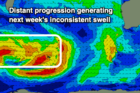
Some new groundswell showing on the charts Wednesday through Friday looks slow and not overly impressive either. It's being generated currently by a broad, slow moving though not overly strong low that's currently west of Heard Island.
Multiple patchy fetches of strong to gale-force W-W/NW winds will likely provide infrequent 3-5ft sets on the South West magnets Thursday, easing Friday. Mandurah may see a tiny 1-1.5ft wave with 1ft surf in Perth.
With the winds swinging back offshore Thursday morning, this looks like a fun morning to pencil in.
Longer term the outlook still looks very slow owing to the positive Southern Annular Mode event, touched on last update, shifting the westerly storm track to the south and away from us. But check back in here on Monday for more details. Have a great weekend!