Our slow run of swell kicks in thanks to SAM

Western Australia Surf Forecast by Craig Brokensha (issued Wednesday 2nd December)
Best Days: Swell magnets for the desperate in the South West tomorrow AM
Recap
The surf cleaned up across Perth and Mandurah yesterday with a drop in swells from Monday, leaving mostly mid-period energy and 2-3ft sets, while Margaret River was 6-8ft and bumpy, best in protected spots.
Today the South West has cleaned up nicely with 4-5ft sets on the swell magnets, back to 1-2ft in Perth and Mandurah.
This week and weekend (Dec 1 - 6)
The swell seen on Monday will continue to ease in size overnight, bottoming out tomorrow morning ahead of some new mid-period SW energy later in the day, peaking Friday morning.
Winds tomorrow will be favourable through the morning with a light E/SE-SE breeze across the South West, but with only small 3ft leftovers. Further north cross-shore S/SE winds are expected with tiny surf.
The new mid-period swell isn't expected to have any real size with Friday offering 3-5ft waves on the South West swell magnets, 1-1.5ft in Perth and Mandurah.
Winds now look a little worse as well with onshore W/SW winds kicking in on dawn across the South West, S'ly to the north, shifting strong SW into the afternoon.
The strengthening onshore winds will be linked with a strengthening but relatively weak (in our swell window) mid-latitude front firing up south-west of us Friday.
A small mid-period S/SW swell is expected Saturday but only to 3-4ft+ or so in the South West, tiny to the north. Winds will also remain average and moderate to fresh from the S tending S/SW.
Unfortunately Sunday isn't looking any better with the swell easing under S/SE tending S/SW winds, bottoming out Monday with cleaner conditions.
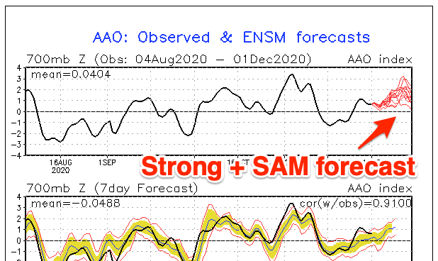 As touched on last update, the longer term outlook remains minimal swell potential wise and this will be linked to a positive and possibly strong Southern Annular Mode event through the middle of the month.
The SAM is an indication of how north or south the westerly storm track is, and when positive the storm track is restricted to polar latitudes and suppressed, vice versa when negative.
So with the + SAM event the outlook is slow, but we'll continue to provide updates Friday and next week.
Comments
Craig, we’ve had two weeks in a row where a solid real-time swell reading on the Rotto swell buoy hasn’t resulted in the usual head high plus waves for that size. On Tuesday with 2.5 m @rotto it was 1-2 foot in Mandurah at best, exactly the same as the previous Sunday week. Any ideas why? The swell direction both days was wsw.
It'd likely be the strength of the swell and direction? Monday/Tuesday was mostly mid-period energy and in the end a bit south of south-west.
The Mandurah and Cottesloe buoys generally do fairly well when assessing inshore size in my opinion.