Fun, large swell filling in through the week

Western Australia Surf Forecast by Craig Brokensha (issued Monday 23rd November)
Best Days: Protected spots Wednesday afternoon and evening, Thursday morning, Saturday morning, Sunday morning, Monday
Recap
Fun waves across the South West on the weekend with two pulses of W/SW swell, cleanest yesterday morning while to the north conditions were good but the surf small to tiny.
Today the South West magnets are the go again with the swell easing in size but with a light offshore wind.
This week and weekend (Nov 24 - 29)
The surf is expected to remain on the small side tomorrow but with less favourable winds, SE pre-dawn across the South West and swinging S/SE on dawn, with S/SE-SE winds further north. Winds will then shift strong SW mid-morning across the South West, later to the north.
This will be due to a front clipping the state, spawning off a strong low that's currently forming in a trough, south-west of us.
This low will generate a great, slow moving fetch of gale to severe-gale W/SW winds in our south-western swell window this evening and tomorrow morning before pushing east tomorrow evening, under the country.
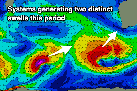 A large SW groundswell should result, building Wednesday and peaking into the afternoon to 8ft+ across the South West, 3ft in Mandurah and 2-3ft in Perth.
Winds will favour protected spots Wednesday as the swell builds with a fresh to strong S/SE breeze, stronger S/SW-S into the afternoon.
Thursday looks great with an E/SE offshore in the South West, E/NE to the north along with the easing SW groundswell from 6-8ft in the South West, 2-3ft in Perth and Mandurah.
A secondary weakening low come trough will bring an onshore change late morning Thursday, lingering out of the S/SW into Friday, with S/SE winds further north.
The earlier stages of this low will generate a moderate sized pulse of W/SW swell for Saturday as winds swing back offshore from the E/SE in the morning.
A fleeting fetch of slim, severe-gale to storm-force W/SW winds around the Heard Island region this evening will project north-east and towards us while weakening, with the swell coming in Saturday to 5-6ft+ in the South West, 2ft in Mandurah and 1-2ft across Perth.
The swell looks to ease on Sunday with SE winds, while into early next week, a new S/SW groundswell is on the cards, generated by a slow moving polar front. At this stage the size looks decent and large for the South West along with S-SE winds, but more on this Wednesday.
Comments
You wrote:
Thursday looks great with an E/SE offshore in the South West, E/NE to the north along with the easing SW groundswell from 6-8ft in the South West, 2-3ft in Perth and Mandurah.
However, surf forecast area has SW winds (metro) for THURS...what's the discrepancy about?
And I should say I've noted your next comment which is that the winds will go SW late morning so will the greatness of THURS be relegated to the near dawn hours?
T-Diddy I think that’s why we all read these forecaster notes. It’s a human making a call based on a combination of experience and the computer models, versus just a computer model. I’ve found these forecaster notes are far more accurate, so my money would be on offshore winds thursday in Perth & Mandurah (but get out there early).
I agree with your assessment but the 2 statements - THURS looks great and SW winds late morning seem to stand in opposition.
Morning T-diddy, will get back to you through the morning. It's a tricky and interesting outlook for Thursday morning.
I probably should have put more detail into the wind evolution through Thursday and been more explicit that the morning was the go. Here's a more in depth look.
On Thursday morning a surface trough with a small embedded low is forecast to move offshore and the axis will sit just north of the Perth region, with offshore winds south of the trough line and onshore winds to the north.
Both models are showing Perth should see offshore winds early, though swinging NNE around 8am and then onshore from the W/NW by 11am. Winds will remain offshore longer further south.
Here's EC's forecast..
11pm Wednesday evening (onshore)

2am Thursday morning (offshore)

5am Thursday morning (offshore)

8am Thursday morning (cross-shore)

11am Thursday morning (onshore)
