Large swells but pesky winds

Western Australia Forecast by Craig Brokensha (issued Wednesday 26th August)
Best Days: Tomorrow, dawn Friday, protected spots Saturday, Sunday
Recap
Great conditions across all locations yesterday morning with a drop in swell, clean again today in Perth and Mandurah but bumpy across the South West.
This week and weekend (Aug 27 - 30)
With the small surf days out of the way, we then look to the moderate to large W/SW tending SW groundswell event due over the coming days.
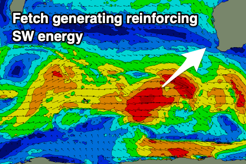 There’s been no real change to the expected size or timing of the swells, but the tail of the conveyer belt of frontal systems moving through our swell window has kept wagging south-west of us, keeping wave heights up into Friday and Saturday morning. This will have a negative impact on the local winds though as detailed below.
Size wise the first pulse of slightly less consistent W/SW groundswell should build to 8ft+ across the South West tomorrow, 2-3ft in Mandurah and 2ft+ across Perth, with Friday holding a similar size but from the SW and most consistent into the afternoon.
The swell should then ease Saturday from 8ft in the South West, 2-3ft across Mandurah and 2ft in Perth, mixed in with some weak localised SW swell from a front moving through Friday.
Locally winds tomorrow morning look early and E/NE across the South West, E/SE further north but we’ll see winds quickly shift N/NE but hold into the afternoon, with sea breezes to the north. Friday looks OK at dawn with the front slightly delayed resulting in dawn E/NE-NE winds but a strong W-W/NW change will move in mid-morning, lingering through Saturday unfortunately and from the S/SW. Perth and Mandurah may see early S’ly winds but we’ll review this Friday.
Sunday should become cleaner across all locations with a morning E/NE offshore, N’ly into the afternoon.
 Size wise the South West looks to be a fun 6ft+ though mid-period energy, 2ft to maybe 3ft across Mandurah and 2ft in Perth.
Into next week our large new W/SW groundswell from a strong mid-latitude low is on track, but the low now looks more significant and it’ll carry strength while moving into us. This will bring an XL, long-period W/SW groundswell.
The longevity and strength of severe-gale to storm-force winds will produce the XL energy, with it arriving Monday afternoon and peaking Tuesday but with strong NW winds, tending SW Tuesday. Wednesday still looks onshore as the swell eases unfortunately, but more on this Friday.