Very windy and average period ahead

Western Australia Surf Forecast by Craig Brokensha (issued Friday 7th August)
Best Days: Today, selected spots tomorrow
Recap
Pumping waves across the South West with clean conditions and easing surf from 8-10ft, 3ft across Mandurah on the sets, while the SW direction only reached 2ft+ or so across Perth.

Dawn yesterday
This morning conditions were great again but the swell on the ease with slower 4-6ft sets in the South West, 2ft Mandurah and 1-2ft across Perth.
This weekend and next week (Aug 8 - 14)
Our current swell will continue to ease into tomorrow, but a new inconsistent and long-period SW groundswell should fill in through the day and build back to at least 6ft across the South West magnets (if not the odd bigger 8ft cleanup), 2ft+ in Mandurah and 1-2ft across Perth through the afternoon.
The only issue are the local winds and the'll become strong from the NE, persisting all day and possibly even stronger late.
Come Sunday it'll be a very poor weather and surf day as the groundswell eases with gale-force N/NE-NE winds as a broad and significant mid-latitude low moves in from the west.
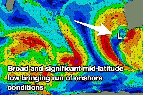 Now, the structure of this mid-latitude is different to others we've seen this season, with it taking a meridional (north-south) alignment and aiming most of its swell generating fetch north towards Indonesia.
On its northern flank though a fetch of strong to gale-force W/NW-W/SW winds will generate a large stormy swell for the northern reaches of the state, but this will then filter down into the southern zones later Sunday and Monday as the low slips slowly south.
Perth and Mandurah are due to see stormy waves Monday to 4-5ft out of the W/NW along with strong W/NW tending W winds. Margs will be a little delayed in timing but also kick into the afternoon with stormy 10ft surf on offer.
The backside of the low will move in on Tuesday with the swell easing slowly while easing from the W/SW and then SW on Wednesday.
Onshore winds will continue to be strong through the backside of the swell event owing to the slow moving nature and weakening of the low, with strong W/SW breezes Tuesday as the swell eases from a similar size to Monday.
Wednesday will see strong easing SW winds as the swell continues to fade, with cleaner conditions due Thursday across Perth and Mandurah with a S/SE breeze but no size.
Longer term there's nothing significant on the cards with patchy mid-latitude storm activity through the Indian Ocean which will move across to us bringing more onshore winds and average swells. More on this Monday though. Have a great weekend!