Large swells to come with improving though strengthening winds

Western Australia Surf Forecast by Craig Brokensha (issued Friday 31st July)
Best Days: Saturday, dawn Sunday in the South West, Sunday morning Perth and Mandurah, Monday, Wednesday, Thursday
Recap
Great waves across Perth and Mandurah yesterday morning to 3ft with offshore tending light onshore winds, poor down in the South West.
Today onshore winds have persisted across the South West with a large new SW groundswell to 10-12ft, workable around Perth and Mandurah early with variable winds and to 3ft across the latter, smaller in Perth.
This weekend and week (Aug 1 - 7)
Today's large pulse of SW groundswell should ease into tomorrow and we'll see winds finally starting to improve across the South West. Conditions are looking better than expected on Wednesday and a light offshore E/NE wind due across the central to north part of the cape, more S/SE to the south, with E'ly offshores further north.
Afternoon S/SW winds will kick in around Perth and Mandurah with winds remaining variable across the central to northern section of the cape. Size wise easing sets from 8-10ft are expected in the South West, 2-3ft Mandurah and 2ft+ Perth.
We then look at our large new pulse of long-period SW groundswell for Sunday.
The polar frontal progression linked to this which has already generated a fetch of severe-gale to storm-force winds is now projecting towards us while producing a weaker gale-force fetch.
 The swell should be consistent and large, peaking Sunday to 12ft+ across the South West, 4ft in Mandurah and 3ft on the sets across Perth. Winds for Sunday now look dicey though with a light dawn S'ly breeze in the South West, shifting W and then strengthening from the SW as a weak trough deepens and turns into a strong low. Perth and Mandurah will be cleaner with variable winds, swinging onshore mid-afternoon.
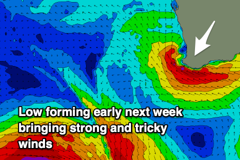
This low will influence the winds on Monday but it's expected to drift north up the coast bringing strong and tricky E/SE winds across the South West, E/NE further north, stronger from the SE into the afternoon.
We'll see Sunday's swell easing fairly rapidly, back from 8ft+, 2-3ft in Mandurah and 2ft+ across Perth.
Tuesday looks smaller again and not ideal in the South West with stronger SE winds as the low continues to influence us.
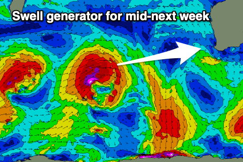 Moving into the middle to end of the week, the low is expected to weaken and track east resulting in easing offshore winds while a large new W/SW groundswell is due to fill in.
The models are in agreement regarding the source of this swell, that being a strong mid-latitude low forming south-east of Madagascar tomorrow, projecting a fetch of severe-gale to storm-force W/SW winds through our western swell window. The low is then due to dip south-east and possibly strengthen, but the models diverge regarding this possibility and follow up SW groundswell.
Either way we'll see a large long-period W/SW groundswell arriving Wednesday and building to 8-10ft across the South West, 3ft in Mandurah and 2-3ft across Perth. This will be with those favourable E/SE offshore winds, but we'll confirm this on Monday. Have a great weekend!