Onshore, offshore, onshore, offshore

Western Australia Surf Forecast by Craig Brokensha (issued Wednesday 22nd July)
Best Days: Friday, selected spots Saturday morning, Sunday
Recap
New signs of swell showed across the South West yesterday morning with inconsistent but clean and windy 4-6ft sets, while into the afternoon the swell became more consistent but conditions deteriorated as N'ly winds increased.
Perth and Mandurah were OK early, poor into the afternoon. This morning all locations have a bit more swell but the wind was into it from dawn across the South West, a touch better further north though not great.
This week and weekend (Jul 23 - 26)
Looking at tomorrow and we'll see a mid-latitude front push into us, linked to the strengthening N/NW winds on the coast today.
This will bring a strong W/SW change before dawn tomorrow and kick up a poor quality stormy and mid-period W/SW swell across all locations. The front is a little weaker than forecast on Monday and the South West looks to come in around 6ft to occasionally 8ft, building to 3ft across Mandurah and 2-3ft in Perth through the day.
Our window of cleaner conditions Friday is still on track with variable tending E/NE winds due across all locations and this will likely see the South West not great at dawn but improving through the day and then N/NE-N into the afternoon.
 Size wise the South West looks to ease back from a weak 5-6ft on the sets, 2ft+ in Mandurah and 2ft on the sets across Perth.
Moving into the weekend we'll see the next strong mid-latitude frontal system pushing in from the west-southwest and this will bring poor and strengthening N/NE winds on Saturday morning, shifting N/NW-NW into the afternoon along with a new long-period W/SW groundswell.
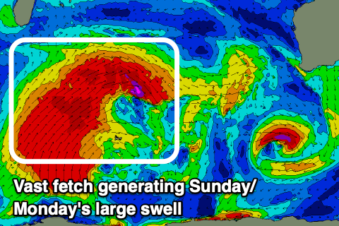
This first swell has been generated the last couple of days by a great polar storm west of the Heard Island region, producing a fetch of severe-gale W/SW winds.
Piggy-backing back up and over the top of this storm is broader and further north located frontal progression, with a fetch of gale to severe-gale SW-W/SW winds now being projected east towards us.
This will be long-lived and the longevity of W/SW groundswell from this source should draw out from Saturday through Monday.
Size wise Saturday's pulse should be around 6-8ft+ across the South West, 2-3ft in Mandurah and 2ft across Perth but with those strengthening and deteriorating winds.
Sunday/Monday's still looks the biggest with sets building to 10ft to occasionally 12ft across the South West, 3-4ft in Mandurah and 3ft in Perth.
There'll also be some additional mid-period W/SW energy from the front moving through Saturday though this is still forecast to dip away quickly to the south-east, resulting in variable tending E/SE winds again across all locations, likely variable into the afternoon.
Monday morning should be a similar size across all locations but the swell easing and with poor, strengthening N tending N/NW winds with the next approaching front.
This next front and the ones to follow won't have windows of cleaner conditions between them as the node of the Long Wave Trough pushes in and across us, bringing front after front up and into the state.
This will see oversized and building onshore surf through next week, likely peaking Thursday/Friday and then cleaning up next weekend as it eases. More on this Friday.
Comments
Bit of a change from yesterday..