More windows opening up for a surf

Western Australia Forecast by Craig Brokensha (issued Friday 17th July)
Best Days: Perth and Mandurah tomorrow, Sunday, Monday, Thursday protected spots, Friday
Recap
Poor conditions across Margs again yesterday with large, onshore surf, average in Mandurah but OK across Perth with early N/NE winds.
Today all locations are poor with large surf continuing but with no quality.
This weekend and next week (Jul 18 - 24)
We’ve got one more day of onshore winds and then conditions should finally settle for a few days before the next front moves in.
 We’ll see the mix of mid-period and long-period W/SW energy from today easing tomorrow but a secondary polar front projecting a fetch of SW winds towards us today will weaken and push into the state tomorrow, bringing fresh to strong W/SW-SW winds across Margs. Perth and Mandurah are still looking clean though and the pick with variable winds.
Size wise the South West should ease from 10ft range on the sets, 3ft across Mandurah and 2ft to possibly 3ft in Perth.
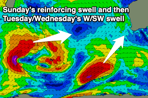
Sunday will be smaller, but a reinforcing S/SW groundswell from the polar front is due to fill in, keeping the South West around 6-8ft (rare bigger one magnets into the afternoon), 2-3ft in Mandurah and 2ft+ across Perth.
Winds will finally improve and swing from SE to E/SE through Sunday morning so the early might not be the cleanest, but getting better towards midday. The afternoon should still be OK in protected spots as well with a S/SE-SE breeze.
Come Monday we should see the S/SW groundswell easing back from 6ft+ in the South West, 2ft+ across Mandurah and 2ft in Perth on the sets but inconsistent.
Winds will be favourable early and E/NE, moderate to fresh in strength and then swinging more NE through the morning, N/NE into the afternoon.
This will be ahead of an approaching mid-latitude low, forming west-southwest of us and then dipping south-east Tuesday evening. As a result winds will strengthen further from the N/NE on Tuesday and then swing NW into the afternoon.
A new inconsistent W/SW groundswell should be in the water generated by a patchy storm that’s currently south-east of Madagascar.
The system isn’t well constructed and as a result we’ll not see the full size potential from the core severe-gale winds. Instead inconsistent 5-6ft waves are due in Margs, 2ft across Mandurah and 1-2ft in Perth.
A secondary possibly slightly bigger W/SW groundswell should move in and take the place of Tuesday’s swell on Wednesday but with persistent N/NE tending NW winds, strong in strength, conditions will remain poor.
We’ll hopefully see the low clear Thursday, swinging winds back to the S/SE but strong, better Friday though quickly around to the E/NE.
A small mid-latitude front pushing in Thursday looks to generate some short-range W/SW swell, but of greater significance is a large, long-period W/SW groundswell due Friday/Saturday.
 This will be generated by a great looking polar storm forming west of Heard Island Sunday, with a broad fetch of severe-gale to storm-force W/SW winds forecast to be projected east through our south-western swell window.
The storm will break down around Heard Island, with a secondary weaker front piggybacking it, extending the longevity of the swell and coming from a more westerly direction.
At this stage we should see a slow increase in size Friday to 8ft+ across the South West by late in the day, 2-3ft in Mandurah and 2ft+ across Perth with E/NE tending NE-N/NE winds, onshore Saturday. We’ll have a closer look at this Monday though. Have a great weekend!