A couple of windows before the onshores kick back in

Western Australia Surf Forecast by Craig Brokensha (issued Wednesday 24th June)
Best Days: Perth and Mandurah tomorrow, selected spots in Margs, keen surfers dawn Friday Perth and Mandurah
Recap
Terrible conditions with an oversized and building XL swell on the coast yesterday, easing into today as onshore winds backed off a little but persisted.
This week and weekend (Jun 25 – 28)
The strong low linked to yesterday's stormy swell has slipped south but is stalling and still aiming a broad fetch of strong SW winds through our swell window.
With this we'll see the current W/SW energy easing and tending more SW tomorrow, remaining solid though continuing to ease slowly.
Conditions will improve across Perth and Mandurah with a light to moderate morning E/NE-NE breeze, shifting more N/NE through the day. Margs is likely to see areas of lighter N/NE winds at dawn though quickly swinging back to the N/NW.
Size wise Mandurah should still see 3ft sets, 2ft to occasionally 3ft across Perth, while the South West looks to come in around 8ft+.
Friday looks less favourable with less size and strong NW tending W winds across the South West, N/NE early in Perth and Mandurah but on the small side.
Saturday looks like a lay day for all locations with a strengthening NW breeze (possibly lighter N'ly at dawn in Perth and Mandurah) with no new swell due until later in the day.
A new long-range SW groundswell due later in the day and more so Sunday will be overshadowed by locally generated increases in swell Sunday as the first of a series of significant and damaging mid-latitude fronts strengthen and project into the state.
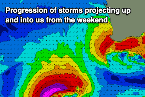 This will be under the influence of a strong and slow moving node of the Long Wave Trough, with it due to influence our weather and surf early-mid next week.
An initial mid-latitude front pushing into us Sunday will bring strengthening NW-N/NW winds and building W/SW swell, while a secondary more elongated front moving in Sunday evening will bring even more size ahead of the strongest front come low which will produce severe-gale to storm-force W/SW winds on top an active sea state Monday and Tuesday morning.
What this will all result in is building large and stormy surf across all locations, becoming XXL on Tuesday/Wednesday (the models diverge a little) from the strongest of the fronts and along with gale-force onshore winds Monday, strong Tuesday. At this stage expect stormy surf to 15-20ft in the South West, 6ft+ across Mandurah and 3-5ft in Perth.
We may see conditions improve across Perth and Mandurah Wednesday morning as the swell eases, still onshore in the South West, and then possibly more variable winds across the South West Thursday. More on this in the coming updates though.
Comments
Cranking up north today. Under gunned but extreme fun!
Yew! Lucky you!! Cold and miserable and wild and wooly down South!! Enjoy.