Large swells from the weekend though the winds..

Western Australia Surf Forecast by Craig Brokensha (issued Friday 27th December)
Best Days: Perth and Mandurah tomorrow morning and dawn Sunday, protected spots Monday, Tuesday morning, protected spots Wednesday and Thursday
Recap
Monday afternoon's large swell eased back to the 6ft range across the South West yesterday, 2-3ft in Mandurah and Perth and winds were good early to the south before shifting mid-morning. Perth was also fairly clean with Mandurah bumpy but workable.
Today the swell has eased off in size and we've got bumpy, onshore 4-5ft waves in the South West, 2ft in Mandurah and 1-2ft in Perth.
This weekend and next week (Dec 28 – Jan 2)
The surf will likely steady through tomorrow morning across the state with the arrival of a weak mid-period SW swell from the front moving through today.
The South West will remain average and onshore with a moderate W/SW breeze and surf back to 3-5ft, while Perth and Mandurah should continue at 1-2ft with more favourable morning S/SE winds.
A mid-latitude frontal system linked to new swell on Sunday and Monday will edge into the state on Sunday bringing strong W'ly winds to the South West, W/SW to the north but initially variable at dawn.
This frontal progression is currently west-southwest of us and generating a great fetch of elongated gale to severe-gale W/SW winds. A large long-period SW groundswell is due from the progression, filling in Sunday and peaking through the day to 8-10ft across the South West, 2-3ft in Perth and Mandurah but with that onshore breeze.
The dawn session in Mandurah are worth a look with the early variable breeze and a touch less size mostly likely to 2ft.
 We've got a secondary mid-latitude storm due to move in on Sunday, though the fetch looks weaker with strong W/SW-SW winds being aimed through our swell window.
A reinforcing but mid-period SW swell is due off this system Monday, maintaining 8-10ft surf across the South West, 3ft in Mandurah and 2-3ft in Perth.
Winds will remain less than ideal across the South West but OK for protected locations and out of the S/SW Monday morning, S/SE-SE further north ahead of sea breezes.
Tuesday is still the pick with offshore E/SE winds across the South West, E/SE-SE further north and with easing sets from 6ft+ or so in the South West, 2-3ft in Mandurah and 2ft across Perth.
Wednesday morning might be a little dicey with winds swinging back to the S/SE across all locations with a building mid-period swell ahead of a better groundswell Thursday.
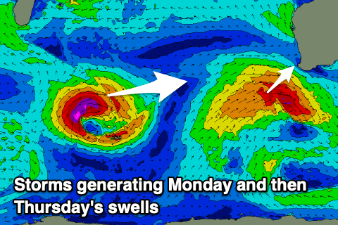
Both swells will be generated by the same system, that being a strong mid-latitude low forming south-east of Madagascar tomorrow and generating a fetch of gale to severe-gale W/SW winds in our western swell window, weakening while pushing east of a position north of Heard Island.
The low will outrun the swell with some mid-period swell building Wednesday ahead of the inconsistent W/SW groundswell on Thursday.
Size wise the groundswell should peak to an inconsistent 8ft on the sets across the South West swell magnets, 2-3ft in Mandurah and Perth.
Winds look as if they'll be strong from the S/SE, but we'll have a closer look at this on Monday. Have a great weekend!