Much better outlook ahead

Western Australia Surf Forecast by Craig Brokensha (issued Wednesday 27th February)
Best Days: Saturday morning all locations, Sunday morning across South West magnets, protected spots Tuesday, Wednesday morning, Friday week morning
Recap
Another morning of good fun surf yesterday morning in the South West with clean 3ft+ sets, tiny to the north. Today the swell has bottomed out and with deteriorating winds and conditions.
Today’s Forecaster Notes are brought to you by Rip Curl
This week and weekend (Feb 28 – Mar 3)
Tomorrow will be another lay day across the state with no new significant swell, but this will likely be the smallest the coast will be over the coming couple of weeks with a return to larger groundswells and good winds.
Firstly on Friday the tail end of a weakening front will bring onshore SW winds and a building mix of mid-period SW swell and windswell.
The earlier stages of this front yesterday and today are seeing a good fetch of W/SW gales aimed towards us through our western swell window, and this should produce a fun W/SW groundswell for Saturday morning
Margs should see 6ft to occasionally 8ft sets with 2-3ft waves in Mandurah and 2ft surf in Perth and winds look to improve, tending light SE across all locations (S/SE around Cape Leeuwin).
The swell should ease into the afternoon and further Sunday with better E/SE offshore winds.
Monday looks to be a lay day as the swell continues to fade with S/SE winds.
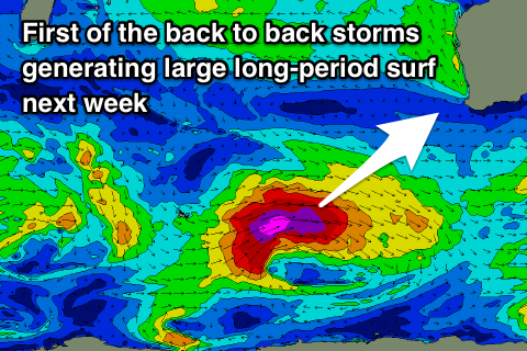 Into next week we've got two back to back long-period SW groundswells due across the state, generated by back to back storms firing up south-west of us.
The first will develop this weekend in the Heard Island region with severe-gale to storm-force W'ly winds projected through our south-western swell window.
The groundswell should arrive Tuesday and build rapidly to a large 10-12ft across the South West, 3-4ft in Mandurah and 2-3ft in Perth with gusty S/SE winds, favouring protected spots. A better SE offshore is expected on Wednesday morning as the swell eases, while our next swell is due to arrive late Thursday and Friday.
The storm generating this next swell will be similar in strength but a touch broader in scope and forming more in our south-western and southern swell windows.
Similar sized surf, if not a touch smaller is expected on Friday morning when it peaks with a SE offshore, but more on this in our next update.
Comments
Welcome Autumn! The return of larger swells and diminishing crowds, happy days!
Yep, how good!
Finally some waves!
CAn't wait!!