Average weekend, great run of large clean surf from Wednesday

Western Australia Surf Forecast by Craig Brokensha (issued Friday 8th September)
Best Days: Wednesday onwards across all locations
Recap
Tiny around Mandurah and Perth yesterday and today, while Margs saw clean waves in the 3ft range yesterday, a touch bigger this morning.
This weekend and next week (Sep 9 - 15)
The surf should remain small into tomorrow and conditions should be clean early across the South West with a variable breeze, but W'ly winds are due to kick in mid-late morning. If you're desperate hit the magnets for infrequent 3ft+ sets.
From Sunday the surf should slowly build, coming in large Monday.
This large swell is being generated by a strong polar low that's currently between us and Heard Island. A broad fetch of strong to gale-force SW winds are being aimed towards us, with stronger core severe-gale winds.
This low will stall today, weakening this evening before projecting a fetch of strong SW winds towards us tomorrow morning and then pushing off further east.
 We should see the swell building through Sunday, reaching 6ft+ later in the day across the South West and 1-2ft around Perth and Mandurah, peaking Monday to 8ft on the sets and 2ft+ respectively.
Winds on Sunday still look onshore and from the W/NW across the South West, while Perth and Mandurah will see light offshore winds, but only tiny surf during the morning.
Monday looks onshore everywhere with a S/SW tending gusty W'ly breeze across the South West, and W tending SW breeze further north.
The strengthening onshore wind will be linked to a strong mid-latitude front pushing in from the west, with a fetch of gale to severe-gale W'ly winds due to be generated right through our close-range SW swell window.
We should see this swell build through Tuesday afternoon, peaking overnight and easing Wednesday.
Sets are due to reach 8-10ft later Tuesday, easing from the 6-8ft+ range Tuesday morning. Perth and Mandurah should build to 3ft on the sets, easing from 2-3ft Wednesday.
Winds Tuesday are still poor with SW onshores, but our offshore wind for Wednesday is on track with a ridge of high pressure expected to move in, bringing light E/NE winds across the South West and E/SE winds further north before giving into afternoon sea breezes.
The swell will continue to ease into Thursday with variable tending light offshore winds during the morning.
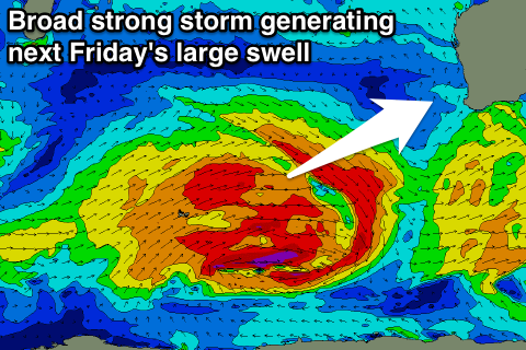
Come Friday another large SW groundswell is due (all linked to a strong node of the Long Wave Trough), produced by a very broad and strong polar low forming between us and the Heard Island region again.
This low looks larger than the current system and should in turn generate larger SW groundswell for Friday coming in around 8-10ft across the South West and 2-3ft to the north.
Winds look favourable and offshore at this stage, making the second half of next week, one to pencil in the diary. We'll confirm this Monday though. Have a great weekend!