Oversized surf for the coming days

Western Australia Surf Forecast by Craig Brokensha (issued Monday 12th June)
Best Days: Late Tuesday Perth and Mandurah, Wednesday and Thursday experienced surfers, Friday morning, Saturday, Sunday morning
Recap
Average waves Saturday with small surf and less than ideal winds, while a new swell for Sunday came in under expectations with clean conditions but only surf in the 4-6ft range across the South West and 2ft further north.
Today the swell has eased back to the 3-5ft range across the South West with clean conditions again and 2ft waves holding in further north.
This week and weekend (June 13 – 18)
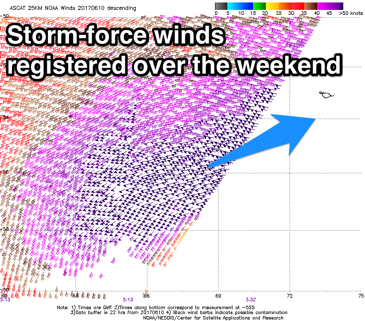
Over the weekend the remnants of a large storm that impacted South Africa drifted south-east into the Southern Ocean, re-intensifying just west of Heard Island.
Satellite observations have picked up a great sustained fetch of storm-force W/SW winds through our south-western swell window, generating a large long-period SW groundswell for tomorrow afternoon.
On top of the active sea state generated by this initial front fetch was an additional fetch of severe-gale W/SW winds projected closer to the state and more in our western swell window, producing an additional similar sized reinforcing W/SW swell for Wednesday.
 We should see a rapid increase in size through tomorrow, with 4-5ft+ surf early, building strongly to the 12ft range late in the day/on dark with possible 15ft cleanups.
Wednesday should then see the swell hanging in around 12ft to occasionally 15ft across magnets most of the day before easing back from the 10ft+ range Thursday.
Perth should build to 2-3ft by dark tomorrow, holding around 3ft Wednesday (3-4ft Mandurah) and easing from 2-3ft Thursday.
Winds are tricky still with an approaching trough bringing N/NE breezes tomorrow morning ahead of a S/SW tending S/SE change late in the day across the South West, more variable to the north.
Wednesday will be best in semi-protected spots with a SE offshore, tending S/SE through the day. Thursday will be excellent with a moderate E/SE offshore, tending S/SE into the afternoon again.
The easing trend will be slowed into the end of the week as some reinforcing W/SW swell fills in later Thursday and Friday generated by a mid-latitude front passing through the southern Indian Ocean over the coming days.
A secondary stronger mid-latitude front generating W/NW gales over the active sea state generated by the front before it should produce a noticeable increase in SW groundswell for Saturday with wave heights expected to build back to the 6ft+ range across the South West through the day and 2ft in Perth and Mandurah.
Conditions look to remain great with morning offshores (with a weak SW change Friday and variable Saturday afternoon).
Winds will tend more NE into Sunday as the swell eases.
Longer term there's plenty more activity brewing for our region into next week although winds might be an issue. More on this Wednesday.
Comments
The new swell has just hit the Cape Naturaliste buoy. 20s.
Current Cape Naturaliste readings aren't too impressive at all. See what tomorrow brings.
I bet if you could see it the near shore bombies would be 12ft on the sets, at that period for sure.
Albany buoy has raced ahead of the bunch, bigger on the southside.
http://www.srosurf.com/allwabuoy.html
http://www.bom.gov.au/products/IDS65030.shtml
22.3 sec forerunners
Nice!!