Reality hits with average outlook

Western Australia Surf Forecast by Craig Brokensha (issued Wednesday 17th May)
Best Days: No good days
Recap
A drop in swell with cleaner but still less than ideal conditions across all coasts yesterday, best in protected spots.
This morning the surf has cleaned right up but as expected, there was no size left at all.
This week and weekend (May 18 – 21)
Even smaller waves are due tomorrow and an early gusty N/NE wind will create average conditions, deteriorating further into the afternoon as winds tend more NW.
Come Friday we'll see a long-range SW groundswell filling in but with poor onshore and strengthening W/NW winds.
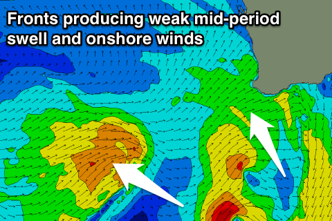
These increasing westerly winds will be linked to an approaching mid-latitude low with some mid-period W/SW swell due to follow into Saturday followed by a secondary increase Sunday as another front pushes into us.
 Saturday's swell looks to come in around the 6ft+ range, with wind speeds within the swell producing fetch not really reaching the gale-force range.
Perth looks to build to 2-3ft, but conditions will be poor with SW tending NW winds ahead of the next front.
The secondary front will be slightly stronger, moving in early Sunday morning and kicking waves up to 6-8ft in the South West (holding 2-3ft around Perth) but with strong W'ly tending SW winds.
We should see the swell easing back Monday but another weaker front approaching from the south-west will continue to direct SW winds across the South West.
Depending on the strength of this final front we may see more variable tending light offshore winds in Perth Monday morning, but we'll review this Friday.
Tuesday may see more variable winds in the South West but the swell will be small by then.
Longer term, the possible large W/SW swell flagged for later next week isn't on the cards any more with the models weakening the developments in the south-west Indian Ocean. Instead we're looking at moderate sized swells with hopefully lighter winds.