A couple of good solid days this week

Western Australia Surf Forecast by Craig Brokensha (issued Monday 16th January)
Sign up to Swellnet’s newsletter and receive the West Australian Forecaster Notes and latest news sent directly to your inbox. Upon signup you'll also enter the draw to win a surf trip to P-Pass for you and a mate (there's only 2 weeks left to go). It doesn’t get much easier so click HERE to sign up now.
Best Days: Tuesday morning, Wednesday morning in the South West, Friday morning, Saturday morning in the South West
Recap
A rapid easing in swell overnight Friday leaving small fun 4ft waves across the South West but with much cleaner conditions and 1-1.5ft waves around Perth.
Sunday was small to tiny with increasing onshore winds.
Today a strong new W/SW groundswell has filled in with bumpy 6ft+ waves in the South West and 1-2ft waves in Perth. We should see the swell peaking this afternoon to 6-8ft and 2ft+ respectively (2-3ft in Mandurah) but with those onshore winds.
This week and weekend (Jan 17 – 22)
Today's strong building WSW groundswell will ease back slowly through tomorrow and Wednesday, due to the slow moving nature and longevity of the low that generated it.
Margs should ease back from 5-6ft or so on the reefs and 2ft in Perth and Mandurah with a morning offshore SE wind. We'll likely see S/SW sea breezes kick in mid-afternoon and then back offshore late in the day around Margs.
Wednesday should see a straighter E'ly offshore and fun 3-5ft sets across the South West, 1ft+ to the north.
Thursday isn't looking too good as the swell bottoms out with a S'ly tending S/SW breeze, but our new SW swell due into the end of the week has been upgraded a little.
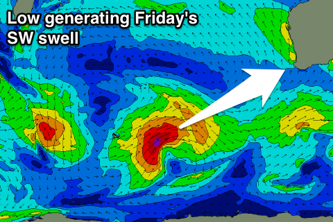 Currently a polar low is forming in the Heard Island region and we'll see a small fetch of gale to severe-gale SW winds projected north-east towards us over the coming days.
The swell should arrive overnight and peak Friday morning to a solid consistent 6ft+ across Margs and 2ft in Perth, easing into the afternoon and further Saturday.
A couple of weaker trailing fronts should slow the easing trend Sunday with 3-4ft sets continuing across the South West, but only around 1ft in Perth.
Conditions on Friday are looking good with a light offshore E/SE across all locations ahead of S/SW sea breezes and similar if not more E/NE winds Saturday morning. Sunday is looking average as early light winds give into a SW change as a weak front moves in from the south-west.
This front will be linked to another moderate to large sized but mid-period SW swell, generated by a weakening but persistent polar front projecting towards us. A peak in swell is due Monday from this system but with onshore winds. More on this Wednesday.