Large swell to end the week, best in protected spots

Western Australia Surf Forecast by Craig Brokensha (issued Wednesday 11th January)
Sign up to Swellnet’s newsletter and receive the West Australian Forecaster Notes and latest news sent directly to your inbox. Upon signup you'll also enter the draw to win a surf trip to P-Pass for you and a mate. It doesn’t get much easier so click HERE to sign up now.
Best Days: Friday morning protected spots, Saturday morning, Tuesday morning
Recap
A good pulse of SW groundswell yesterday to 5-6ft in the South West and 1-2ft further north along with favourable morning winds.
Today the swell has eased back to 3-5ft in the South West and 1ft in Perth with 1-2ft sets around Mandurah, again with morning offshore winds.
This week and weekend (Jan 12 - 15)
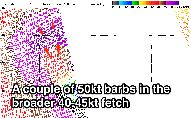
The mid-latitude low responsible for Friday's W/SW swell has formed and wind speeds are a touch weaker than forecast on Monday. Satellite observations have picked up a fetch of severe-gale W/SW winds, with a couple of 50kt barbs but we're mainly due to see winds stay below that storm-force threshold.
 We'll still see a large groundswell generated, with it due to arrive during the early hours of Friday morning peaking around 10ft in the South West and 3ft on the sets around Perth.
A slight drop in size is expected into the afternoon but overnight it'll drop away more considerably, with easing from 4-6ft Saturday morning in the South West and 1-2ft in Perth.
Winds tomorrow will be poor with a strong SW'ly and late increase in mid-period SW swell, while Friday we're looking at S/SE winds in the South West (SE up in Perth) so protected locations will be best. Saturday will be much cleaner as the swell eases with an E/NE offshore before sea breezes kick in.
Sunday looks average with small to tiny surf early, ahead of a mid-period in W/SW swell through the afternoon but with S/SW winds.
Next week onwards (Jan 16 onwards)
As talked about last update, another broader but weaker low forecast to form north-east of Heard Island tomorrow, and project a slow moving fetch of W/SW gales through our western swell window again.
The slow moving nature of the low will help produce a moderate to large W/SW groundswell for Monday, building to 5-6ft+ in the South West and easing off slowly from 6ft or so Tuesday.
Perth should see good 2ft waves through Monday and Tuesday.
Conditions on Monday are an issue with a S'ly tending S/SW breeze, while Tuesday should see a morning SE'ly. We'll have another look at this Friday.
Comments
Couple more 50kt barbs showing on satellite passes overnight..
Classic spike in swell often associated with captured fetches..