Easing improving surf, fun swell Tuesday then large clean swell to end the week

Western Australia Surf Forecast by Craig Brokensha (issued Friday 6th January)
Sign up to Swellnet’s newsletter and receive the West Australian Forecaster Notes and latest news sent directly to your inbox. Upon signup you'll also enter the draw to win a surf trip to P-Pass for you and a mate. It doesn’t get much easier so click HERE to sign up now.
Best Days: Saturday morning Perth, Sunday morning Margs, Monday Margs, Tuesday both coasts, Wednesday morning Margs, Friday everywhere
Recap
Tiny onshore waves across Perth and Mandurah yesterday, while the South West had more size but nowhere to surf.
Today a messy and stormy swell has risen across all locations with messy 6ft sets in the South West and 2-3ft waves to the north. The surf will continue to build through this afternoon as the mid-latitude low impacting the state holds its intensity through until this afternoon before weakening and moving east overnight.
This weekend (Jan 7 - 8)
With the low currently impacting the South West due to weaken and move east overnight, we should see the swell dropping away, but the low will stall a little longer than ideal around Margs.
With this S/SW winds will persist tomorrow with easing surf from the 6ft range. Perth should see a morning S/SE-SE breeze and easing 2ft+ waves.
Sunday will be cleaner but smaller again and only maybe 3-4ft in the South West (tiny to the north) with a morning SE breeze (E/SE Perth).
Next week onwards (Jan 9 onwards)
Our SW groundswell for early next week is still on the cards, with two separate increased likely to be seen.
Currently a relatively weak but persistent front moving in from the Heard Island region should produce an increase for Monday, building to 4-5ft into the afternoon across the South West and 1-1.5ft in Perth.
A secondary system moving over the top of the initial front should generate a slightly better increase for Tuesday coming in at 4-6ft, with Perth due to hang around 1-1.5ft (2ft sets Mandurah).
 SE winds look to persist Monday and Tuesday, while Wednesday looks great at exposed breaks as the swell eases with a light E/NE offshore ahead of sea breezes.
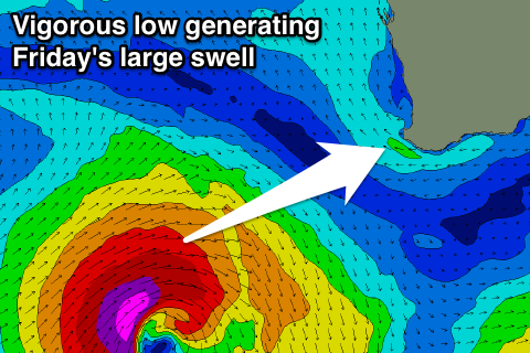
Into the end of the week we've got a large and likely clean W/SW groundswell on the cards.
A weak surface trough south-east of Madagascar will combine with a weak cold front, deepening into an intense and almost 'bombing low'.
We should see a fetch of severe-gale to storm-force W/SW winds aimed towards the South West, before the low dips south-east out of our swell window.
A large powerful long-period W/SW groundswell is due off this low, kicking very late Thursday and peaking Friday with offshore E/SE winds due to the low dipping south-east and a ridge of high pressure moving in.
The South West should see 10ft+ surf with 2-3ft waves in Perth. We'll have a closer look at this Monday though, have a great weekend!