Good swell tomorrow, easing but clean from Sunday

Western Australia Surf Forecast by Craig Brokensha (issued Friday 30th December)
Sign up to Swellnet’s newsletter and receive the West Australian Forecaster Notes and latest news sent directly to your inbox. Upon signup you'll also enter the draw to win a surf trip to P-Pass for you and a mate. It doesn’t get much easier so click HERE to sign up now.
Best Days: Protected breaks tomorrow, Sunday morning Margs, Monday morning Margs, Tuesday morning Margs, Wednesday morning Margs
Recap
A workable 4ft of swell in the South West yesterday morning with cleaner conditions, while Perth and Mandurah were also fun (1-2ft in the later).
This morning the swell was a touch smaller but conditions cleaner, with magnets in the South West providing the biggest and best waves.
This weekend and next week (Dec 31 – Jan 6)
The new long-range W/SW groundswell due to build through today is showing on the Cape Naturaliste buoy with peak periods above 17s.
We should see sets hitting 5-6ft+ across the South West by dark but with average conditions, holding tomorrow morning around a similar size.
There'll be long waits between sets so you'll have to be patient. Perth should offer infrequent 1-2ft waves.
Winds tomorrow aren't ideal with a S/SE breeze across most locations (likely tending SE around Perth) before sea breezes kick in.
Sunday is looking much cleaner with a morning E/SE offshore and easing 4-5ft sets in the South West, 1-1.5ft around Perth.
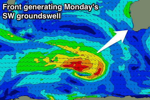
Our SW groundswell for Monday is still on track, with the polar low generating it, producing a a fetch of strong to gale-force W/NW winds through our south-western swell window this morning, easing tomorrow.
 Margs should hold around 3-5ft Monday with tiny waves up in Perth, easing back Tuesday and further Wednesday.
Conditions are looking good again across the South West with a morning E/SE offshore ahead of sea breezes. Tuesday and Wednesday are also looking clean as a surface trough sits just west of us, keeping S/SE breezes at bay.
Another small SW groundswell is due Thursday, produced by a relatively weak front pushing through the southern Indian ocean, coming in at 3-4ft+ or so.
Conditions are a little hard to pin down at the moment due to the trough in the region, but we'll look at this again Monday.
Longer term a slightly bigger SW swell may be seen late week/next weekend, but check back Monday for an update on this. Have a great weekend and Happy New Year!