Large long-period W/SW groundswell but with dicey winds

Western Australia Surf Forecast by Craig Brokensha (issued Friday 4th Novemeber)
Best Days: Saturday before mid-afternoon sea breezes in the South West, Monday morning protected spots, early Tuesday both coasts, possibly Wednesday morning
Recap
Tiny waves have continued around Perth and Mandurah today and yesterday, while the South West offered bumpy 3-4ft waves yesterday, cleaner and a touch bigger today.
This weekend and next week (Nov 5 - 11)
There's been no real change to the long-range but strong W/SW groundswell due over the weekend and earl next week.
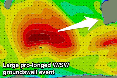 Earlier this week a vigorous and slow moving low aimed a sustained fetch of 50-60kt winds towards us, before weakening slightly but remaining at strength in our far swell window near Heard Island.
22s fore-runners are due to be seen on the buoys early tomorrow morning, with the groundswell building through the day and showing more so from midday and into the afternoon.
Swell magnets in the South West should build from 3-4ft tomorrow morning to 6-8ft by dark, with 1-2ft waves showing late in Perth.
A peak is then due Sunday to a strong 8ft in the South West, with 10ft bombs and 2ft+ waves around Perth.
A very slight drop in size may be seen Monday, but more so Tuesday, down from 6ft+ in the South West and 1-2ft around Perth.
Winds are the only issue, with S/SW breezes due across all coasts Sunday at the swells peak.
As the swell builds tomorrow though, an offshore E/SE breeze is expected, tending variable mid-afternoon ahead of sea breezes. So to get the most size, maybe aim for a midday surf.
A morning S/SE'ly is still on the cards for Monday morning ahead of S/SW sea breezes, and then Tuesday is looking a little dicey with a variable tending light offshore wind likely ahead of a W/SW change.
Wednesday may play out similar as the swell continues to ease, but we'll have to review this Monday.
Through the rest of the week some fun SW swell energy is due from less than favourably aligned but persistent mid-latitude frontal activity through the Indian Ocean.
Size wise it's not due to get above 4-6ft or so and winds also look dicey, but more on this Monday. Have a great weekend!