Large swells, oversized Monday with light winds

Western Australia Surf Forecast by Craig Brokensha (issued Wednesday 11th May)
Best Days: Perth Monday and Tuesday morning, experienced surfers only in the South West Monday morning
Recap
Finally a clean window revealed itself yesterday morning across the South West with offshore winds and a building swell from 3-4ft. Perth and Mandurah remained tiny.
This morning conditions were clean again with better 4-5ft sets along with an offshore tending N/NE breeze. Mandurah and Perth saw a touch more size to 1-1.5ft.
This week and weekend (May 12 – 15)
The SW swell seen through Tuesday afternoon and today will easy back through tomorrow from 3-5ft through the morning and 1ft+ further north around Mandurah and Perth.
Conditions will be average though with a strengthening N/NW breeze across the South West and N/NE tending NW winds further north.
This will be related to a strong mid-latitude frontal system pushing in close to us, at the head of a much strong and more vigorous polar frontal progression which developed west of Heard Island yesterday.
What we should see is building mid-period W/SW swell through Friday ahead of a couple of larger W/SW groundswell pulses through Saturday and Sunday.
The South West should build to an easy 6ft+ through the day, with 1-2ft waves developing in Perth, ahead of the larger groundswell kicking to 10-12ft by dark Saturday in the South West and 2-3ft in Perth. Sunday should then see easing surf from a similar size.
Conditions will be poor though with NW winds continuing Friday across the South West (N/NE tending NW around Perth) and then fresh and gusty W'ly tending W/NW winds Saturday.
Into Sunday we'll start to come under the influence of a very strong and powerful mid-latitude low with strong NW tending W'ly winds and an oversized swell for Monday, discussed below.
Next week onwards (May 16 onwards)
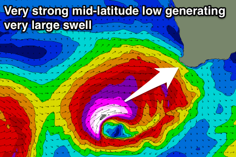 As touched on above, an intense mid-latitude low is expected to deepen significantly west-southwest of us Friday evening, generating a fetch of storm to hurricane-force W/SW winds while projecting towards us.
The low will move at a similar speed to the swell its generating resulting in a captured fetch scenario, with an oversized swell due to be created for exposed breaks across the south-west and south of the state.
This swell is due to see a strong but short-lived peak Monday morning, with 15ft sets across exposed breaks in the South West (larger at deep water offshore reefs) while Perth should kick to a solid 3-4ft through the mid-morning.
Winds are actually due to become more than workable as the low moves off quickly to the east resulting in E/NE tending variable winds around Perth and variable (from the N'th) tending fresh NW winds across the South West.
Not too far behind another strong polar front is forecast to project up towards us, generating another large swell for Wednesday with variable winds also on the cards. More on this Friday.
Comments
Some lovely small lines refracting in across the banks and gutters between Scarbs and Trigg.
Tim wintons 'The nautilus' for real