Large swells to come but with poor winds

Western Australia Surf Forecast by Craig Brokensha (issued Monday 9th May)
Best Days: Keen surfers South West tomorrow and Wednesday mornings
Recap
A new pulse of S/SW groundswell across the South West for Saturday but with onshore winds, easing back through Sunday with more workable but still average S'ly winds.
Perth saw choppy 1-2ft surf on Saturday, easing back from a cleaner but tiny 1-1.5ft Sunday.
Today tiny clean waves were seen across Mandurah and Perth with variable winds but a small leftover 2-3ft of swell across Margs.
This week and weekend (May 10 – 15)
From tomorrow through Thursday a couple of small to moderate sized SW groundswells are due, generated by less than favourably aligned frontal systems over the Heard Island region the last couple of days.
An initial pulse tomorrow should kick to 4-5ft across the South West, holding a similar size Wednesday and then easing from 3-5ft Thursday morning. Perth isn't due to get much over 1ft.
Conditions are due to be clean across most spots tomorrow morning with a variable tending NE breeze across the South West and E/NE winds to the north, while Wednesday looks to see moderate NE-N/NE winds down across Margs, freshening and tending more N/NW with Perth seeing NE tending NW winds.
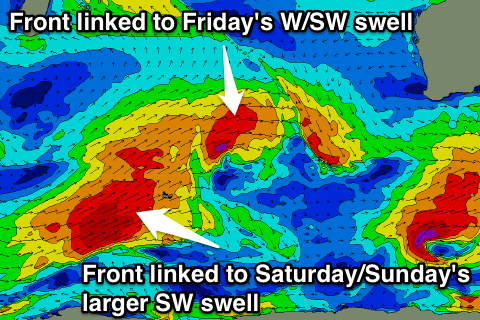 From Friday we'll see a succession of moderate to large W/SW groundswells impacting the state as a series of strong polar front ride high towards us, generating fetches of gale to severe-gale W/SW winds.
The first and smallest system has already formed well north of Heard Island and will track east over the coming days while generating winds in the gale-force range.
A moderate sized W/SW swell is due off this front, filling in Friday and offering 6ft+ waves across Margs and 1-2ft waves up in Perth.
Right behind this small front though will be a stronger and broader system, generating a continued fetch of gale to severe-gale SW winds through our south-west swell window.
A large long-period SW groundswell should result, building through Saturday afternoon ahead of a peak early Sunday morning.
The South West should build to 10ft+ later Saturday and peak Sunday morning to 10-12ft.
Perth should see sets to 2-3ft later in the day, with good 3ft waves Sunday morning.
Conditions Friday look poor with a fresh NW tending W'ly in the South West, increasing across Perth through the day, and then persistent NW winds Saturday (NE tending variable Perth). During the peak of the swell Sunday everywhere will be average as another strong front starts pushing into us, bringing gusty W/NW tending W/SW winds.
This low will generate another large pulse of swell for Monday but more on this Wednesday.