Fun swells with generally offshore winds

Western Australia Surf Forecast by Craig Brokensha (issued Friday 8th April)
Best Days: Protected spots Saturday and Sunday morning, Monday morning, northern corners Tuesday morning, Friday
Recap
Good clean fun waves around 4ft across the exposed reefs in the South West yesterday morning, while today a slight kick in energy was seen to a better but inconsistent 3-5ft with gusty offshores. Perth and Mandurah remained flat.
This weekend and next week (Apr 9 - 15)
Today's slight kick in size was a mix of background SW groundswells, and into tomorrow, a slightly better S/SW groundswell is due to fill in, produced by strong polar frontal activity skirting the edge of our southern swell window.
Exposed breaks in the South West should see 4-5ft+ sets through most of the day, easing late while Perth and Mandurah aren't due to see any size.
Conditions will be wind affected with a fresh to strong SE'ly (possibly tending E/SE at times), increasing into the afternoon.
A slight drop in size is due Sunday to around 4-5ft, with one final pulse of S/SW groundswell for Monday morning from further polar frontal activity on the edge of our southern swell window.
A slight increase back to 4-5ft+ is due Monday morning, easing back slowly into the afternoon and further Tuesday from 3-4ft.
Conditions will be good but windy Sunday with a fresh to strong E/SE breeze holding most of the day, and fresh E/NE tending variable winds Monday.
As the swell eases Tuesday swell magnets will be best with a moderate N/NE tending lighter N/NW breeze.
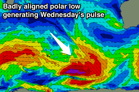 Into Wednesday a slight kick in inconsistent SW groundswell is due from a very strong, but unfavourably aligned and tracking low pressure system south-east through the Indian Ocean. A fetch of severe-gale to storm-force NW tending W/NW winds will be generated perpendicular to our swell window, resulting in much less size compared to if it were generated along our swell window.
The South West is expected to kick back to an inconsistent 3-4ft+, easing back through Thursday. Light to moderate onshore winds will create average conditions Wednesday, with SE winds into Thursday.
Longer term, our inconsistent W/SW groundswell for later in the week is still on track, with a vigorous but distant frontal system forecast to develop south-east of South Africa tomorrow, aiming fetch of weakening SW gales through our western swell window over the weekend and Monday.
The swell will be very inconsistent but good, arriving Friday and reaching 4-6ft across exposed breaks, with the possible bigger bomb under offshore winds. Perth should see more size, with infrequent 1-2ft sets.
We'll have another look at this Monday though. Have a great weekend!
Comments
Blustery is somewhat of an understatement this morning.