Plenty of swell and windows of cleaner conditions

Western Australia Surf Forecast by Craig Brokensha (issued Wednesday 4th November)
Best Days: Early Thursday, Friday protected spots, Sunday in protected spots, Monday morning, Tuesday morning
Recap
Small fun and clean waves in the 3ft range yesterday morning across the Margs region, with tiny surf around Perth.
Today the beginnings of a strong but inconsistent SW groundswell were starting to build with 3-5ft sets on offer this morning, building further this afternoon to an inconsistent 6-8ft at exposed reefs in the South West. Light morning winds created clean conditions and a lighter N/NW breeze this afternoon is keeping selected spots surfable. Perth was slow and around 1-1.5ft but the swell has since kicked to the 2ft range.
This week and weekend (Nov 5 - 8)
The wind outlook for tomorrow morning has become more favourable with a weak low sitting off our coast expected to weaken while remaining west of us.
This should see early variable tending E/NE winds across the South West, and straight offshore E'ly winds around Perth before tending NW into the afternoon.
This afternoon's strong pulse of SW groundswell should ease from an inconsistent 6ft+ across the South West and 2ft+ around Perth, down further into Friday. Stronger SE winds Friday will limit options across the South West, with better early E/SE winds around perth.
Saturday isn't looking too interesting as the swell continues to ease from 3-4ft+ with fresh S/SE winds, with 1ft+ sets around Perth.
Into Sunday our new long-period SW groundswell is still on track, with a surface low that developed over South Africa now being absorbed into the westerly storm track as it moves south-east through the Indian Ocean.
This low will 'bomb' dropping well over 24hPa within 24 hours from 980hPa down to 936hPa tomorrow.
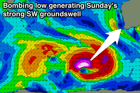
With this, a pre-frontal fetch of severe-gale NW winds will be closely followed by stronger core W/SW winds in the storm to hurricane-force range. The track of the low isn't ideal for us, but the strength is quite significant and we should see a strong kick in SW groundswell to 6-8ft across the South West Sunday morning. There may be the odd bigger bomb in the mix at times.
Perth won't see as much size due to where the swell's being generated with inconsistent 2ft sets due Sunday. Winds Sunday are a little dicey as a SW change approaches, with early S/SE winds giving way to a fresher S/SW change through the day.
Next week onwards (Nov 9 onwards)
Plenty of fun reinforcing SW groundswell is due into Monday and Tuesday next week from a broader and more favourably aligned but much weaker fetch of W/SW winds on the backside of the 'bombing low'. Margs should persist in the 6ft range Monday, with a stronger kick late in the day, easing from 6ft+ or so Tuesday morning. Perth looks to continue to offer 2ft sets.
Winds will be much better for these swells as well with E/SE offshores Monday morning and the E/NE offshores Tuesday morning.
Longer term another good moderate to large SW groundswell is due into the end of the week from a multi-staged polar low, but more on this Friday.