Surf while you can. The end of the week is looking shocking

West Australian Surf Forecast by Guy Dixon (issued Monday 7th September)
Best Days: Tuesday morning, Sunday afternoon, Monday
Recap:
Saturday was shocking right along the coast under brisk onshore breezes so we will concentrate on the better parts of the weekend.
The long awaited large swell finally arrived late on Saturday night and into the early hours of Sunday morning. We had solid 10-12ft surf breaking along the South West, with the offshore bombies around 20ft and inconsistent (the periods just didn't cut it as we expected late in the piece around Thursday’s model update). Conditions were the cleanest further north throughout the morning under light easterly breezes (Cape Leeuwin was observing westerly breezes and Margs was a little raw), then conditions deteriorated and became a bit more chopped up as winds swung north in the afternoon.
Perth and Mandurah were also firing with clean 3-4ft surf under light easterly breezes. A great Father’s Day was had by all.
The surf has since eased to around 8-10ft today, but conditions are looking really good under a light easterly breeze right across the South West.
The morning session was good for Perth and Mandurah today, with 2-3ft surf and light offshore breezes. Winds have swung southwest this afternoon however so the quality has dropped a bit.
This week (Tuesday 8th - Friday 11th):
Tuesday will see a small pulse generated by a northwesterly pre-frontal fetch and southwesterly trailing fetch which has been moving fairly locally throughout today. Due to the modest fetch and wind strengths, this pulse isn’t expected to add any size, but instead slow an easing trend keeping the surf in the 6-8ft range across the South West, and 1-2ft for Perth and Mandurah.
Winds will be light east/northeasterly early across the South West, increasing and tending more northerly throughout the day. As for Perth and Mandurah, the situation will be similar with light/moderate northeasterly breezes first thing, strengthening and tending northerly and potentially onshore later. All in all, it looks like one of those days where the early session is clean and workable, but quickly turns bad as the northerlies come into play.
The surf will fade across all coasts on Wednesday to around 4ft for the South West and 1ft for Perth and Mandurah.
It’s not looking like a good day of surfing, with moderate northeasterly breezes from the get go, strengthening and tending more northerly throughout the day. I’d mark it as a lay day. Get the house work done.
The long period forerunners of fresh swell looks to impact the South West on Thursday generated by a system that will have been moving west of Heard Island on today. We are likely to see a jump in swell size to an inconsistent 4-6ft.
Fresh/strong winds with a local front will also be impacting the coast on this day whipping up a short range wind swell which will add 2-3ft into the mix. There is a slight amount of model disagreement regarding the timing of the front (some say winds will be northwesterly early swinging west/southwesterly, while other just say west/southwesterly from day break following the system). In either scenario, surfing won’t be an option as conditions are likely to be shocking.
This same system will move northeast to relatively high latitudes throughout Tuesday. The fetches don't look particularly strong or broad off this system, but it still has the potential to generate swell in the 6ft+ range for the South West and 2ft+ for Perth to Mandurah due to it’s westerly nature on Friday.
The synoptic set up isn’t looking to be any better for the end of the week. Winds are will be strong west/northwesterly whipping up 8ft of short range swell across the South West (in addition to the aforementioned swell) and 3ft+ for Perth and Mandurah. The surf will be a turbulent, stormy mess with no decent options for a wave.
This weekend (Saturday 12th - 13th Sunday):
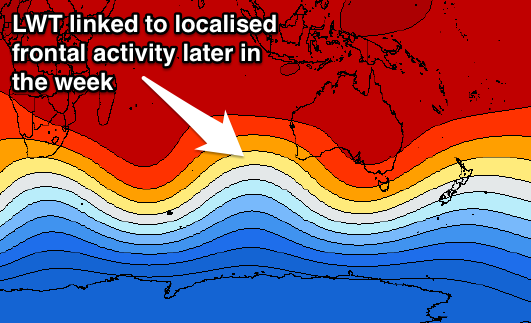
For surfing, the weekend is looking shocking. However if you froth on weather systems, it’s looking pretty impressive. A strong node of the LWT will be active over the eastern Indian Ocean on Thursday and is likely to sling shot a series of fronts/lows/intense fetches towards the South West.
Southwesterly captured fetches of 45—55kt winds will be moving in great alignment towards the South West whipping up a 12-15ft swell peaking late on Saturday. Perth and Mandurah will only see around 2ft of groundswell due to the acute southerly direction, however gusty onshore winds will be whipping up 3-4ft junk.
Gale force southwesterly winds will be lashing the South West and Metro coasts in the morning, remaining strong throughout the day. Surfing is virtually out of the question.
Sunday will see conditions settle as a ridge begins to build over the state. Local winds will ease, and the short range wind swell will dissipate as a result. The groundswell off the polar system will fade, however we will still be left with 8ft surf across the South West, 1-2ft for Perth and Mandurah.
Moderate/fresh south/southwesterly winds will ease from morning across the South West and tend more southerly allowing for the opportunity of a wave at protected locations. Further north, Mandurah will be under a light/moderate flow with Perth light east/southeasterly.
Next week (Monday 14th onward):
A ridge will continue to build allowing winds to ease and become more favourable early next week. The swell window will remain largely dormant for the first half of the week, so an easing/settle trend is in order for all coasts.
Comments
Doesn't look too shabby at Yalls this morning.
Pumping! Looks like Indo.
Great summary guy . Thanks craig . Did the lwt stay in the spot since a week or two back ?
Yeah, having a quick check back on the charts it appears it kind of weakened, stalled and then re-intensified again.