Oversized clean swell Saturday, easing Sunday and into next week

Western Australia Surf Forecast by Craig Brokensha (issued Friday 26th June)
Best Days: Saturday, Sunday, Monday morning, Tuesday morning
Recap
The fore-runners of a very large, powerful and strong W/SW groundswell showed on the Cape Naturaliste wave buoy early yesterday morning and the swell rapidly built from 4-6ft through the morning to an easy 12-15ft+ by dark across Margs (ahead of schedule) but with fresh and gusty NW winds.
The swell dropped back a touch into this morning (due to the swell running ahead of schedule) with infrequent 12ft to occasionally 15ft sets across exposed breaks under favourable and light to moderate S/SE tending E/SE winds. The swell has eased back a touch further this afternoon, and it will continue to ebb and pulse between 12ft to 15ft across exposed breaks through the day due to the sheer magnitude of the storm and tricky nature in nailing each particular pulse.
Mandurah offered clean good 3-5ft sets, with inconsistent 3-4ft waves across Perth, but it was mainly too straight for the beaches.
TV reports of the biggest swell in a decade and other similar hype is unfounded. While the storm was very vast in nature, core winds weren't sustained enough to produce a 1 in 10 year swell event.
In any case, the best pulse of swell (in my eyes) is yet to come tomorrow, but more on this below.
 This weekend and next week (Jun 27 – Jul 3)
A secondary large pulse of slightly more southerly SW groundswell is due across the state tomorrow morning, generated by the most expansive and eastward propagating fetch of severe-gale W/SW winds the last few days.
This should continue to offer inconsistent 12-15ft sets across exposed breaks in the South West with much larger sets at offshore reefs early, easing back through the day. Perth should ease from 3-4ft (with the possibility of the odd bigger bomb at swell magnets) with 10-12ft sets continuing in the North West.
Conditions are looking great with a moderate to fresh offshore E'ly tending variable breeze due across all locations (remaining probably moderate around Perth).
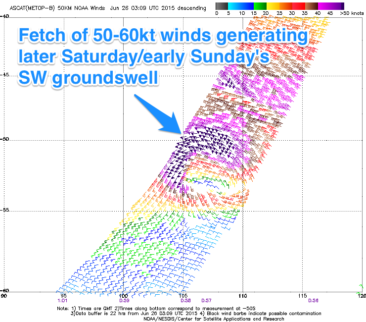
One final pulse of significant SW groundswell is due late in the day Saturday in the South West, easing Sunday. This is being produced by a vigorous polar low that shed off the main frontal progression, with satellite observations this morning confirming a stronger than forecast fetch of 50-60kt W'ly fetch in out swell window.
This low will race off quickly to the east, but a large SW groundswell pulse should be seen, keeping 10-12ft sets hitting exposed breaks in the South West Sunday morning, easing into the afternoon, with Perth easing from an inconsistent 3ft. The North West should drop from 8-10ft.
Winds Sunday will be good through the morning and moderate to fresh from the E/NE, but will tend more NE through the day and likely ease later.
Come Monday as the swell continues to ease, less favourable NE winds are due through the morning, tending more variable from the N/NW into the afternoon.
The easing trend in swell should be slowed into Tuesday as a new W/SW groundswell arrives, generated by a fetch of pre-frontal W/NW gales moving through the Indian Ocean over the weekend.
Margs should ease from 4-6ft with 1-2ft waves in Perth and no real size in the North West as NE winds continue.
Longer term there's nothing too significant on the cards, with a moderate sized SW swell possible later in the week/next weekend, but more on this Monday. Have a great weekend and surf within your ability.
Comments
Pumping North West today..
And how's this set, pure, large and perfectly lined up groundswell. Amazing.
Might be a good time to bring this article back into circulation.
http://www.grindtv.com/travel/7-best-excuses-not-surf-big-waves/#pCQ7Zbd...
Cape Naturaliste kicked again, good to see.
Some bombs on the Margs cam easily as big as forecasted.
Nice, this morning's swell pulse was as noted above, the one I liked the best.